Friday, September 15, 2023

Lewis and Clark Trail

We had a light breakfast, then Mark and Steve walked the dogs in the desert while Mary and Cindy packed for day. On the drive to Salmon, we saw ring neck pheasants and chukkers on the Farm-Market Road from May to Ellis.


While Mark and Cindy were in the Lemhi County tax office, we walked around Salmon. We especially liked the park on the small island in the Salmon River. We met up and ate a late breakfast at Odd Fellows Bakery in Salmon. The restaurant is in an old building that had the Odd Fellows Lodge in Salmon. We had ham and jam croissant sandwiches, then split a bear claw and a molasses ginger cookie. The bakery had a small but nice dining area upstairs. Everything was very good.

Cindy on the Lewis & Clark Trail

We drove by Sharkey Hot Springs and up to the top of the mountain on Forest Service Roads to reach the Lewis and Clark National Historic Trail at Lemhi Pass. We walked along part of the trail that the Lewis and Clark party took over the continental divide. The area is really beautiful with fall flowers remaining in the high mountain meadows. We could understand how the explorers saw such beauty in the area.

At the "Most Distant Fountain"

Our walk at Lemhi Pass took us through parts of Idaho and Montana as the trail winded along. This pass in in the Beaverhead Mountains of the Bitterroot Range at about 8,000 feet elevation. We stopped at the Sacajawea Memorial Area with a small picnic area dedicated to Sacajawea. We took a few snapshots and read interpretative signs on the Lewis and Clark expedition. We also went to “The Most Distant Fountain”, the spring that is reputed to be the head of the Missouri River. It is here that Lewis and Clark met the Shoshoni tribe. Fortunately, the chief of the tribe was Sacagawea’s brother. Although over 200 years have passed since the Lewis and Clark expedition, this area remains virtually unchanged other than a narrow dirt access road that has replaced the footrail.
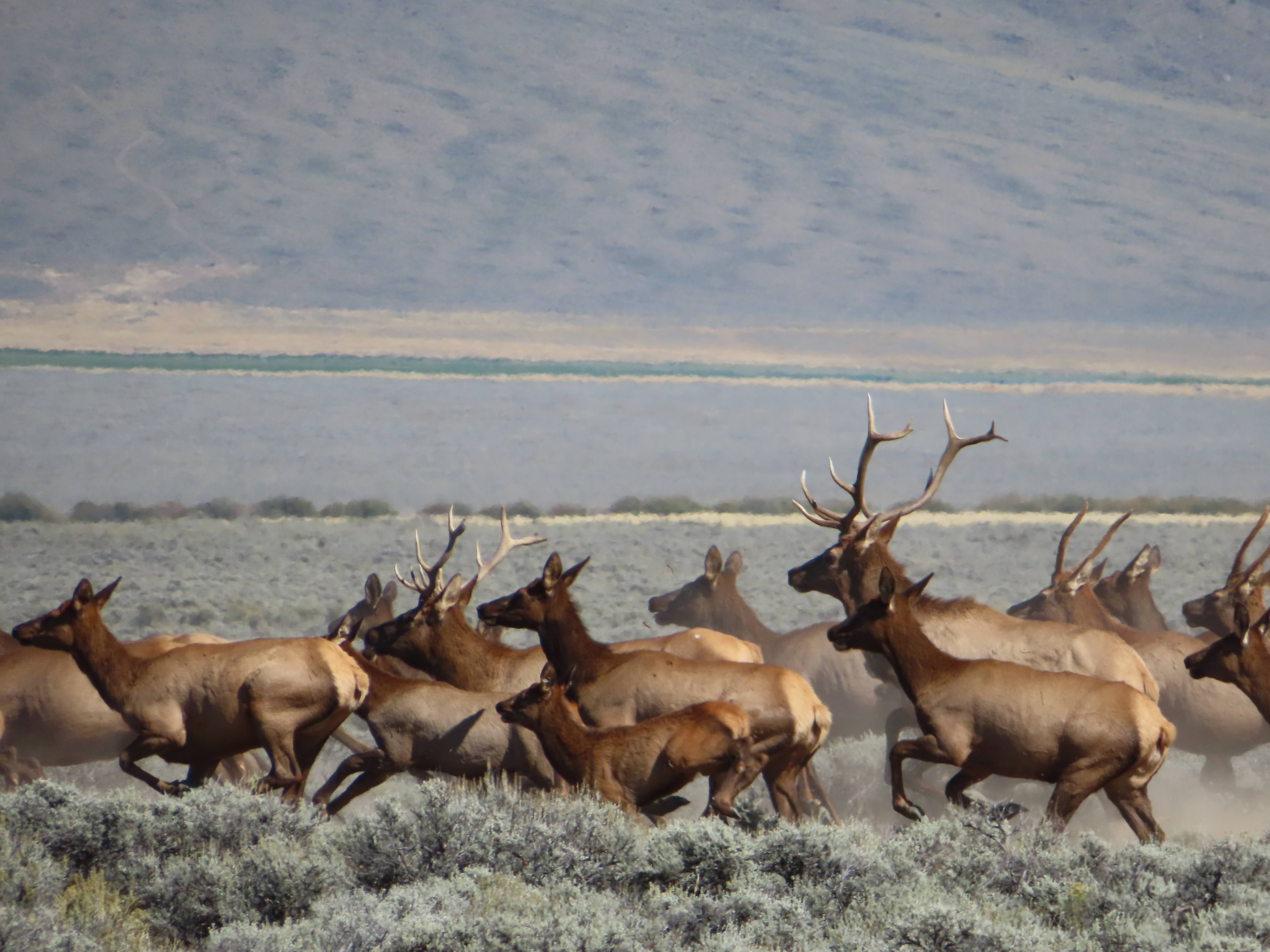
Elk herd near Tendoy

We drove on the Lewis and Clark Trail, coming out at Tendoy, Idaho.  Turning south on ID-28, we stopped at a roadside park with interpretative signage about steelhead and salmon spawning in the area. We continued driving south on Rt. 28 near Lemhi when Mark spotted a mother moose and her two calves. Mark made a quick U turn to go back for photos. The adult moose watched us cautiously, keeping her calves near, but we were able to get a good look at the three of them.

We drove through Leadore on the Nez Perce Trail and toward the town of Gilmore to see the beehive clay charcoal ovens near Nicholia. On Rt. 28 we saw a herd of 75 over elk including several large bulls. Further south on the road, we saw several pronghorns including a herd of over 25 animals.

The Birch Creek Charcoal Kilns were built in 1886 to produce charcoal for the lead and silver mining operations at the Viola Mines about 10 miles east of the kilns. The charcoal was also used at the Nichola Smelter about three miles west of the mines. At one time there were 16 clay brick kilns at this site; each were about 20 feet in diameter and 20 feet tall. Every kiln could produce 1500 to 2000 bushels of charcoal during a two-day run.  Each held 30 to 40 cords of wood, typically Douglas fir, per load.

Birch River charcoal kilns

The ovens were in operation for less than three years when the price of lead fell. The site was listed in the National Register of Historic Places in 1972, and the Forest Service restored the kilns in 2000.

As we drove, we saw a harrier hawk dive down for a ground squirrel. We noticed it because of the especially long wings for a hawk. As we continued the 70-mile drive back to Salmon, we saw the pronghorn and elk herds again but from a distance this time. We also saw deer and sand hill cranes in fields as we drove.

Moose near Tendoy

We decided on the Dusty Mule Bar & Grill for dinner. This is one of the dinner options near Mark and Cindy, so they are regulars at the diner. The restaurant was especially busy this evening, and the waitresses were flying around trying to get everyone served. We were able to get a table without waiting and were not in a hurry to get our meals. Mary, Cindy and Mark had the Friday special, chicken fried steak with mashed potatoes. I went with the black and blue burger, a half-pound patty with blue cheese. The burger was very good and cooked just right. However, the French fries were inedible. They were brown on the outside but completely raw. If struck me as funny to get bad potatoes at a meal in Idaho.

We made the short drive back to the house in May, where we bathed and watched the mystery, Witness for the Prosecution on Acorn.


Thursday, September 14, 2023

May, Idaho

We slept well last night but heard the coyotes singing in the distance. Sound travels well in this flat land, so it is difficult for us to tell how far away something is. We had banana bread for breakfast before taking a long walk in the desert through BLM land. The dogs were happy to go out for a walk with us. As we walked we looked for interesting rocks in the desert that might be good for polishing.

Front of Whittington's Idaho home

Steve and Mark worked on Mark’s Kioti tractor, changing the oil and filters. It didn’t take long since Mark had all of the materials and supplies that we needed. Cindy and Mary did laundry, cleaned the house and worked on updating Cindy’s computer.

Mary and Cindy drove to the Ellis post office to mail estimated taxes and postcards. They saw pronghorn antelope further down Hooper Lane near Custer County.

After lunch, Mark and Steve cut down some dead cottonwood trees in a canal that had been previously used for irrigation. Since the canal is long dry, the trees have died. Before we could start cutting, we had to move the tractor implements out of the path of falling trees. Mark keeps the implements along the fence to the chicken yard, so we moved them over near the driveway.

Tractor implements beside chick pen

Mark was able to notch the trees perfectly to get them to fall along the ditch and avoid hitting the chicken house, fence or the irrigation pivot across the ditch. Just to be sure that the trees fell in the right place, we hitched the tractor to the trees to pull them in the right direction.

Mary and Cindy weeded, deadheaded and started a cacti garden near the house. By dinnertime we were all tired and ready to shower and call it a day. We still had a lot of trees to take down, but they were inside the chicken yard, and we would need to take the fence down before we started sawing. We wanted to be fresh another day and be able to get the job finished in one day so the hens wouldn’t have to be confined to the chickenhouse any longer than necessary.

Mark fixed halibut tacos for dinner with some of the fish that his friend, Rich, brought back from Sitka. Afterwards we finished watching the last episodes of Dark Winds, season 2. Season 1 of the series was based on Tony Hillerman’s book, Listening Woman, and season 2 was his People of Darkness book. We enjoyed both seasons and look forward to additional seasons.

Cindy and Mary sat outside stargazing under blankets. They saw 6 satellites and 1 asteroid as well as clear views of the Milky Way and many stars that we never see in the East. Mark went to the hot tub to relax and stargaze.

Wednesday, September 13, 2023

Craters of the Moon National Monument and Preserve

We left around 7:30 after a good breakfast at the Jerome Day’s Inn that included eggs, biscuits, gravy, Canadian bacon, waffles, plus yogurt, breads, cereal, etc.


Mark drove home to get some chores done at the house. Cindy came with us to Craters of the Moon National Monument and Preserve.

We arrived before the visitor center opened, so we entered the park with the Senior Annual National Park pass and got a map. We had been to this park in 2021, during the pandemic and really enjoyed it. The area is what you would expect from a moonscape and was used to train Apollo astronauts in the 1960s. Our first stop was the 3 small cones: two spatter cones and the snow cone. These cones resembled small volcanoes, although they were created by lava thrown from a larger volcano during an eruption. We then hiked up to the Big Craters area accessed from the North Crater Trail. We hiked the other end of this trail during our 2021 visit starting at the trail head.

Imprint of tree bark in lava

We drove on to the Tree Molds and Big Sink areas. When we were there two years ago, we didn’t hike the 2 mile out and back Tree Molds Trail, so we wanted to be sure to do it this time. At the end of the trail there are impressions of trees in the hardened lava. The molds of the tree bark reminded us very much of alligator skin. While we were on the Tree Molds Trail, we saw a long-tailed weasel. We weren’t certain of the identification, but the ranger at the visitor center confirmed the identity. She told us that they are a rare sighting.

Mary lifting a pumice rock

Since the Tree Molds Trail and the Broken Top Trails share a parking area, we returned to the car for a drink before going on the 1.8-mile Broken Top Trail loop. We had walked this trail two years ago, but the formations and lava tubes are some of our favorites. While in the parking lot, Cindy talked to Robert and Loretta from Bristol, TN. They were a nice older couple who had self-converted their van and travel all over the country in retirement. We met a couple on the trail from Bavaria, visiting western states for month. We enjoyed our visit with them and discussed our upcoming trip to Germany in December. Although their English was very good, we were happy that we were able to converse with them in German as well.

Lava flows at Craters of the Moon

After returning to the car, we drove to and walked the short ½ mile Devils Orchard Nature Trail. The interpretative signage reminded us of the multiple lava flows in the area from 15,000 to 2,000 years ago. Geologists believe that at least nine distinct lava flows account for the variations in the lava in the park.

We stopped at the visitor center to ask about some flowers and the ferret we saw. The visitor center wasn’t open two years ago because of COVID, so we enjoyed looking at the exhibits and chatting with the rangers.

Lava tube at Craters of the Moon

After a lunch of peanut butter, Ritz crackers and some snacks, we left for May about 1:15. We drove through rain north of Arco to Darlington. Acro was the world’s first community to be powered by nuclear generated electricity. In a 1955 experiment a reactor provided electricity to the small town for about an hour. As we drove through the rain, the temperature dropped from 68 to 55. We ran into more rain around Mackey where we saw that the reservoir was being drained to work on the dam. We stopped in Challis for a short stretch break, then on to Hooper Lane where Mark had penne pasta with hot sausage and tomatoes for dinner.  We watched two episodes of Dark Winds, season 2 after dinner.

We went out onto their deck after dark to look at the stars. Very little light pollution exists in the area since ranches here are far apart. Also, with very little humidity in the air and no clouds in this semi-arid environment, the night sky is very clear. So many stars visible that we could hardly make out the common constellations. The Milky Way formed a clear, diagonal band across the sky. While the sky watching was excellent in 2021 compared to the east, the western fires produced a great deal of smoke, somewhat obscuring the sky. However, this year there were no major fires, and the sky was perfectly clear.


Tuesday, September 12, 2023

Golden Spike National Historic Monument

As usual, we woke early and had a cereal breakfast with the last of the Israeli cantaloupe from Green River. After cleaning up the house in preparation for leaving, we took a walk around Price. We wanted to run a few errands in Price and needed to wait until the museum and post office were open. We were glad to see that the wave pool in Price was still in operation, although closed now for the season. The college, now Utah State University Eastern and the Price city park were still there and seemed to be doing well. We returned to the house and finished cleaning up and packing.

We stopped at USUE Prehistoric Museum for postcards and to browse the gift shop. To our surprise, they had no dinosaur cards, but we got some postcards of the San Rafael Swell and other attractions from the area to send to friends. Cindy and Mark went to Walmart for gas, which was 25 cents per gallon cheaper than everywhere else. We planned to meet at the Golden Spike National Historic Monument in Promontory UT.

We drove the familiar Route 6 over the Wasatch Range to Spanish Fork, Utah. It is a very beautiful drive through Utah’s “Castle Country” with the sheer rock canyons bordering US 6 through the mountains. We stopped before we picked up I-15, and Mary drove the busy 6 lane highway (each way) until north of Salt Lake City. Fortunately, the traffic wasn’t as bad at this time of day as it is during rush hours. We left I-15 near Corinne, UT, taking US 83 west to the Golden Spike National Historic Monument. 

The Jupiter at Promontory Summit

We arrived at Promontory Summit, Utah, shortly before 1:00 PM. Our Interagency Senior Annual National Park Pass got us into the park at no fee. A ranger program was just beginning as we arrived. Her program was excellent, telling the history of the site and the joining of the Union Pacific and the Central Pacific railroads as the “Wedding of the Rails.” Prior to the opening of the transcontinental railroad, travel from the Missouri River to California by wagon took six months. In addition, the trip was very dangerous; many travelers died along the way. 


The ranger dispelled a lot of the stories that we learned in school about the event and told of problems that arose during the last days of the project in 1869. We learned that there were actually four commemorative spikes. A golden spike from California, later given to Leland Stanford Museum; a silver spike was given by the state of Nevada. The Arizona Territory provided an iron spike plated with gold and silver, and the San Francisco New Letter brought a second golden spike. A laurelwood crosstie was laid for the special spikes with holes predrilled to accept the ceremonial spikes whose metal would be too soft to drive. Immediately following the ceremony, the tie and spikes were removed and replaced with a pine tie and iron spikes. A telegraph wire was attached to the final spike to the nation could hear the spike being driven. The whereabouts of two of the four ceremonial spikes are unknown today.

Another story that we found interesting regards the flag flying over the park which had only twenty stars despite the fact that the United States had thirty-seven states in 1869. It seems that no one remembered to bring a flag to the 1869 ceremony. When the organizers realized the omission, they found that a soldier in attendance had a 1818 flag in his personal baggage that was a family memento. It was flown over the ceremony.

A replica of the Jupiter (Central Pacific Railroad) was on display and drove up and down the track for a short distance for onlookers. On weekends, both the Jupiter and No. 119 (Union Pacific Railroad) are on the rails at the park.

We walked around the exhibits in the visitor center and bought more postcards to send to the grandkids. Mary got a stamp in her National Park Passport book.

ATK Rocket Garden

To get to Twin Falls, Idaho, we decided to drive on UT-83 west to avoid backtracking to I-15. Shortly after getting on Route 83 north, we happened upon the Northrop Grumman testing facilities and the ATK Rocket Garden (Autoliv Thiokol) that displayed rocket engines and gave information about each. For many years Morton-Thiokol made rocket boosters for the space shuttle. They became known following the 1986 Challenger disaster. It is believed that failure of O-rings produced by Morton-Thiokol were responsible for the explosion. The company is also known for producing Patriot and Minuteman missiles and other rockets for the military and space industry. We talked to an employee who was working in the gardens near the rocket displays. He told us about the plants and how they did in the growing conditions of northern Utah.

After leaving we had a car lunch of peanut butter, Ritz crackers, Tillamook cheese and snacks as we drove through the flat ranch land north of Salt Lake City. We picked up I-84 near Blue Creek, Utah, and made the short drive to Idaho, stopping at the second Idaho rest stop for a quick stretch break.

The Snake River from Shoshone Falls

Cindy and Mark were ahead of us. Although we had planned to go to Thousand Springs, Idaho, it had been a long day, and we were ready for a stop. We got gas at Jerome, right across from the Day’s Inn where we were spending the night.

After checking into the hotel, we jumped in the truck with Mark and Cindy and went to Twin Falls where we visited the Shoshone Falls State Park overlook. The Interagency Senior Annual National Park Pass got us in free. The park was beautiful with lots of areas for picnicking, hiking, swimming and boating. This stretch of the Snake River is known as “The Niagara of the West” for the waterfalls that can reach over 20,000 cubic feet per second. However, when we visited some water was coming over the falls, but most went through the adjacent hydroelectric plant. After leaving the falls, we drove the short distance to Dierkes Lake, a former lava quarry forming a small lake with a very nice swimming area.

Shoshone Falls

We stopped at the Twin Falls Costco for dinner splitting a couple of pizzas and chicken Caesar salads, all of which were very tasty. We made a quick stop at Walmart for a few things before returning to the Jerome Days Inn.


Monday, September 11, 2023

Nine Mile Canyon

We had cold cereal for breakfast then packed binoculars, food water and the travel guides for the drive up Nine Mile Canyon.

First petroglyph panel - Nine Mile Canyon

We left the Airbnb around 8 AM to go by the Wellington, Utah, post office to mail postcards. We stopped at Miller's gas station (formerly Walker’s) at the intersection of Nine Mile Canyon Road and US 6 to look for new post cards. Millers didn’t have much choice in postcards, so we picked up one of the guides to Nine Mile Canyon and continued on. We had a small booklet on Carbon County and a link to download an app that provided an audio track that used the phone’s GPS location to provide information on specific rock art, dwelling ruins or a granary. We found the app to be very helpful, giving us good information on finding some of the evidence of the ancient Fremont culture living the area hundreds of years ago. We also used a pamphlet that Emily and Ian had picked up a few years ago when visiting the area.

Nine Mile Canyon

When the girls were small, we visited Nine Mile Canyon almost every summer. Of course, the weather was always sweltering hot while we were there, but we looked forward to it regardless. Back then we would put the kids in the back of a pickup with binoculars to spot sites along the smooth rock of the cliff faces. The road was gravel back then, and we traveled slowly allowing us to see most of the things along the way. At that time we used some old printed material from Boy Scout projects or student research at the College of Eastern Utah as guides to the rock art. Now the road is paved the entire way, and there are many print and electronic resources to help find pictographs, petrographs, dwellings and granaries.

Ruins of a Fremont dwelling  - Nine Mile Canyon

It is believed that the Fremont culture occupied Nine Mile Canyon starting around 300 AD. While they lived about the same time as the Anasazi culture to the south, there is little evidence of interaction between the two. The Fremont built stacked stone semi-subterranean dwellings with vegetation for the roof on benches above the floodplain. They were not only hunter/gathers but also farmed ancestral corn, beans and squash. The stone and mud granaries in cracks of the cliffs may have been used to store grain although some believe that the crops left in these caches were offerings to their deities. It is not certain whether the rock art was an actual depiction of people and animals of the area or whether the forms communicated other meanings. For example, the antlers on a pictograph elk may have communicated the direction and distance to a water source or other important location.

Coyote spreading the stars  - Nine Mile Canyon

After driving about 25 miles out the now paved canyon road, we stopped at the first petroglyph site. These panels have a number of human and animal figures, so we took a lot of snapshots before driving on. We were pleased to spot the petroglyph of Coyote, an important figure in the mythology of the Southwest’s native people. In nearly all cultures, Coyote is a trickster who is not to be trusted and can even bring evil. This petroglyph depicts Coyote placing the stars. According to Hopi legend, Old Spider Woman gives Coyote a sack filled with stars that he was a place in the sky. After climbing to the top of the tallest mountain, he begins placing the stars nearly in the heavens creating the constellations. However, Coyote soon grows weary of placing the stars in the sky and throws most of the stars in the sky explaining why most stars are not neatly arranged.

While stopped along the road looking for a granary, Cindy talked to a girl from Custer Co., ID, who was in the area assisting with the building a Jehovah’s Witnesses church. She was very pleasant and was also enjoying the day in Nine Mile Canyon.

Pregnant buffalo - Nine Mile Canyon

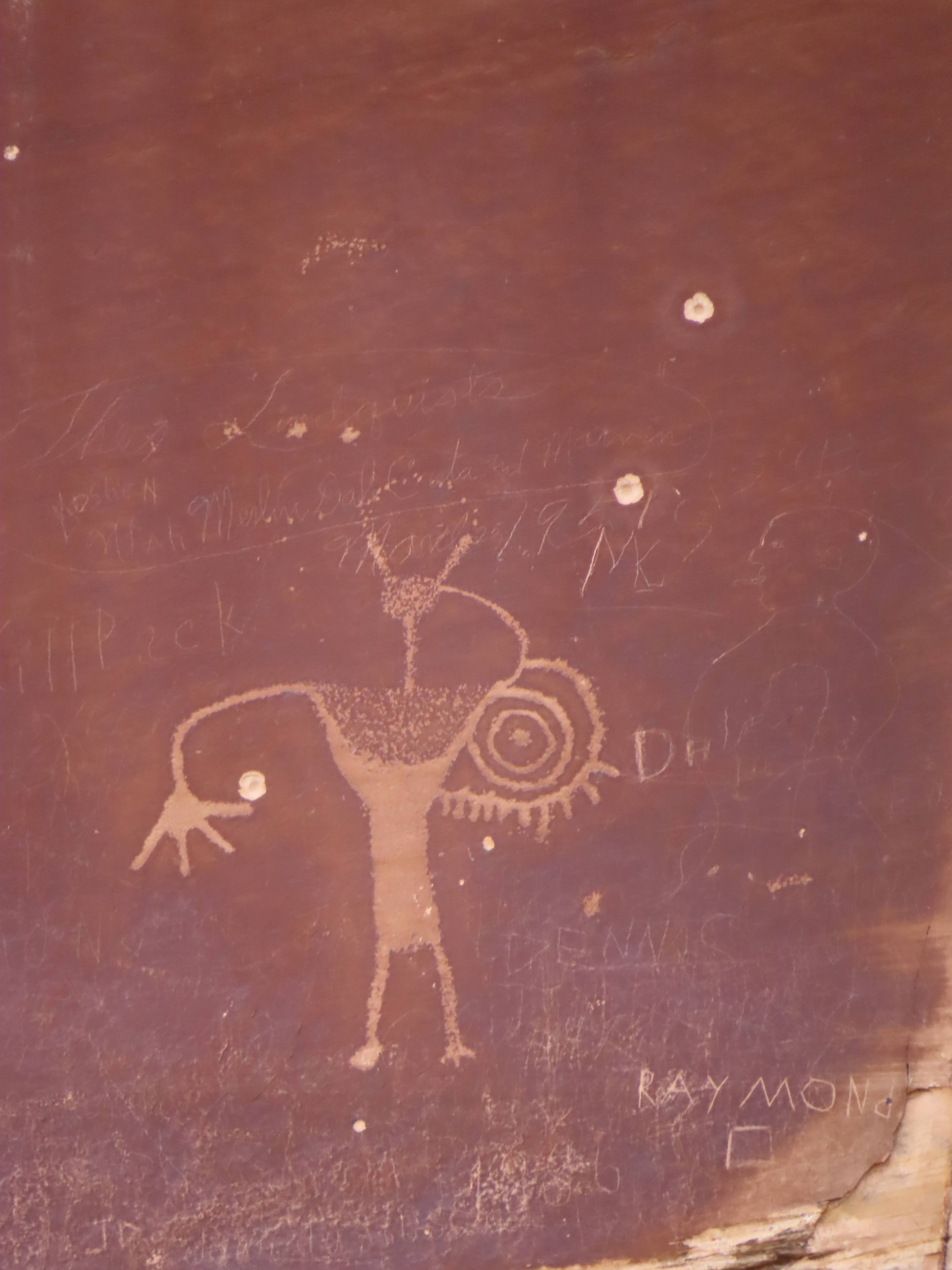
We hiked out to the pregnant buffalo site that appears to show an adult female bison with a smaller bison inside. Like many of the panels in Nine Mile Canyon and other places in the area, there was evidence of activity after the original rock art from nearly 2000 years ago. Ranchers and cowboys in the mid to late 1800s also marked the rocks. In many places more recent additions from the Utes join the ancient Fremont work. After looking at the panels for a time, the newer additions are discernable since the animals appear to be more realistic. In addition, horses and people with bow and arrow are found in the additions made after 1500 AD. Sadly, a good deal of vandalism exists from the 20th century and beyond. Guides to the area implore visitors to not touch the panels, but some vandalism still occurs.

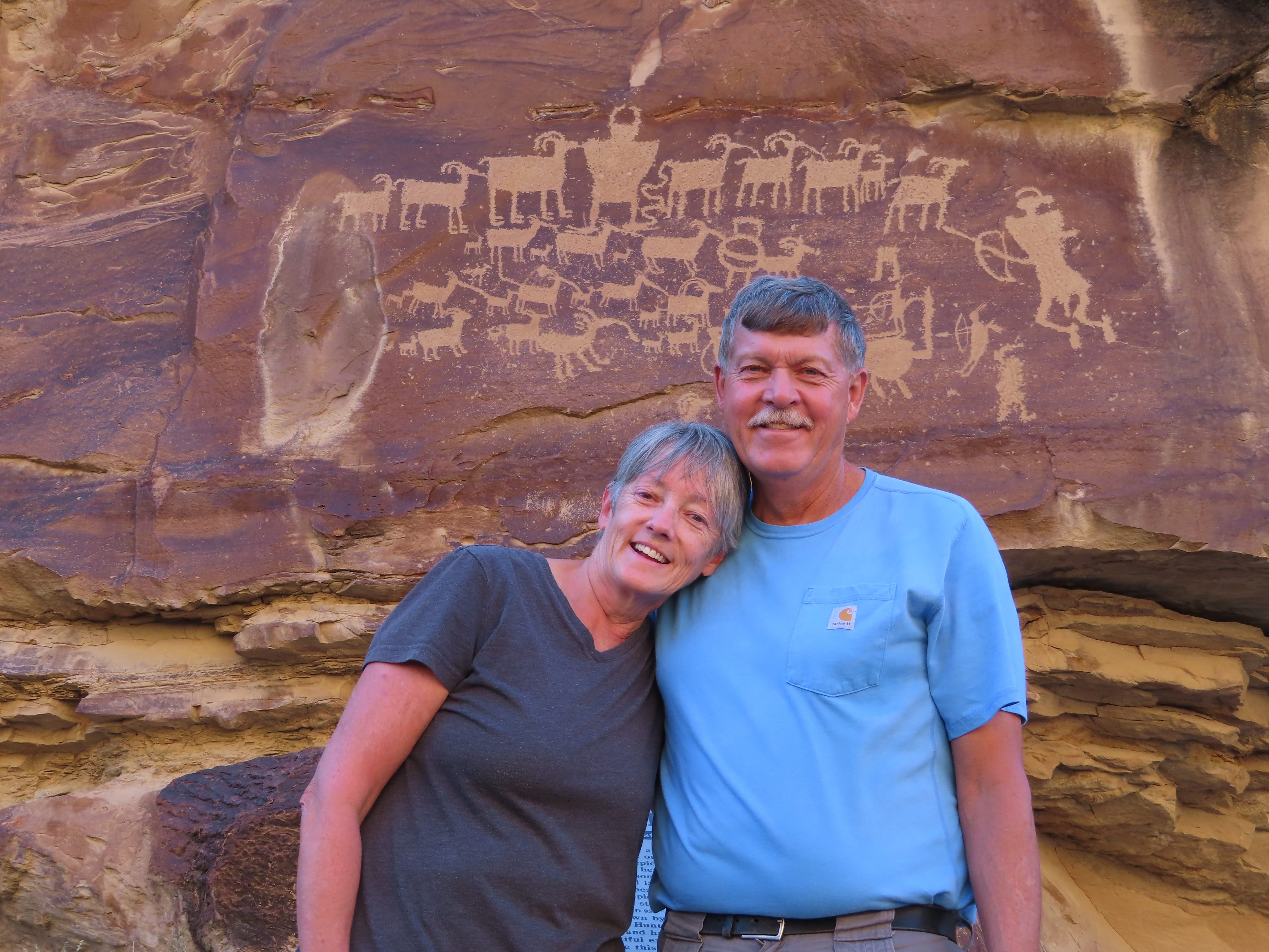
Mark and Cindy at the Great Hunt Panel

Our last stop in Nine Mile Canyon is the most popular panel, the Great Hunt Panel. Photographs of this panel have been printed in many publications including National Geographic. Some archeologists believe that the panel was started as early as 8,000 BC. It has been modified many times since including, more recently, by Utes in the area. This panel includes at least 30 bighorn sheep and 8 human-like figures.

To our surprise, we saw very little wildlife today and only one deer while we were in the canyon.

We got back to Price around 6:30 and stopped at Walmart for bagged southwest salad and General Tso’s chicken from the deli counter. We enjoyed the meal in the kitchen of the Airbnb in Price.

After dinner, we watched another episode of Dark Winds, season 2 before turning in.

Sunday, September 10, 2023

San Rafael Swell

The Airbnb in Price was very comfortable. The house is situated in a quiet neighborhood not far from the college (formerly College of Eastern Utah, now Utah State University Eastern). We had cold cereal and some of the Israeli melon for breakfast. We were happy that the Israeli melon was as sweet and juicy as we were told at the fruit stand.

The "Little Grand Canyon" in the San Rafael Swell

After packing cameras, binoculars, lunch, water bottles, hats and sunscreen, we left the house at 8:00 AM to drive through the San Rafael Swell. At Castle Dale, we took the Green River Cutoff road to reach the Wedge Road. Many people were camping near the wedge overlook. We had a beautiful morning view of the “Little Grand Canyon” area of the San Rafael Swell. We spent a lot of time taking photographs and looking down the canyon at the San Rafael River over 1200 feet below. Comprised of layers of sandstone, the area was uplifted between 40 and 70 million years ago. Throughout this time, the river has been carving through these sandstone layers to form the canyon. Some of the layers include the red Chinle Formation, the Wingate Sandstone, Kayenta Formation, Moenkopi Formation and the newest layer, the Navajo Sandstone, that includes petrified dunes with cross bedded layers of yellow sandstone.

Pictograph at Buckhorn Wash

A few campers were parked around the wedge overlook, but we saw few people moving about. We returned to the Green River cutoff road to reach the road through Cottonwood Wash and Buckhorn Wash. The pictographs at Buckhorn Wash are some of the best in the area. These pictographs are painted on the rocks as opposed to petroglyphs which are pecked into the rock. Experts estimate that these pictographs are at least 1000 years old. It is uncertain whether the images portrayed actual events or were part of a spiritual ceremony. We continue to be amazed at how well these images have survived here. Another nearby preserved dinosaur track is believed to have been made by a carnivorous theropod dinosaur.

Our lunch as we drove was peanut butter and Ritz crackers, with lots of corn nuts, sesame sticks, mixed nuts and fruit.

We made a quick stop at the Swinging Bridge that was built by the CCC in 1938. Until the 1990s, this was the only bridge across the San Rafael River. We took a stretch break here and photographed some of the formations near the bridge.

Wild donkeys at Jackass Flats

At Jackass Flats we saw, unsurprisingly, a herd of wild donkeys. This group of perhaps a dozen animals has been living wild in the San Rafael Swell for many generations and is quite accustomed to visitors driving by. There were animals of all ages including several very cute foals. They didn’t make an effort to run away when the pickup stopped for us to take photos.

Sandstone formations in Goblin Valley

We crossed I-70 to take Heart of Sinbad route south. This road goes near Swayze’s Cabin. It was a rough drive, so Mark turned around shortly afterwards to take I-70 and UT 24 to Goblin Valley State Park. As we drove the temperature dropped from mid 70s to upper 60s with light rain. We saw much more of the main valley due to cooler temperatures. Mary was fascinated with the green Curtis Formation that covered parts of the red Entrada Sandstone. We all agreed that the landscape was beautiful. We remembered going to Goblin Valley in the 1980s and 90s with the kids and walking through the weird formations of sandstone in the desert.

Temple Wash Pictographs

On the drive back, we headed west to the Temple Panel that includes pictographs and petroglyphs that may go back as far as 8000 BC. There appeared to be a mix of older images alongside more modern petroglyphs that could be as modern as 1300 AD. Unfortunately, evidence of vandalism was visible, including bullet holes that are believed to have been made by cowboys or travelers in the 1800s.

Along the drive back to Price on Route 6, we saw pronghorn antelopes as we had seen them many times when we traveled that road with Sarah and Emily when they were young. Sometimes the pronghorns would be near the road, but they were usually pretty skittish and stayed back further.

We had dinner at dinner at Los 2 Amigos in Price. Like most Mexican restaurants, the food and service were both good, and the portions were large. Mary had shredded beef soft tacos, Steve had a combination platter with a shredded beef burrito and chili rellenos. The homemade flour tortillas were very thick, which made the meal very filling. One way back to the Airbnb and picked up a few things at Walmart.

At the house we watched the second episode of Dark Winds season two.


Saturday, September 9, 2023

Rochester Petroglyph Panel

Since we weren’t meeting the Whittingtons until noon, we had a slower start. We got ice and gas ($3.65) at Walmart after our breakfast of cereal and waffles.

Colorado National Monument

We were on I-70 west by 8:45 AM and saw signs in Fruita for the Colorado National Monument. Thinking it was new, we decided to pay a visit. Unfortunately, there was a bike race up the plateau to the monument, so travel was slow up and down. Our Interagency Senior Annual National Park pass got us admission without additional fees. We briefly visited the visitor’s center, Mary stamped her passport, and we walked around looking at the views. The park isn’t new, but we had never visited it before. The CCC built the road from Grand Junction to Fruita in the 1930s. We saw high desert plants and whip tail lizards during our hour visit. We looked for the desert big horn sheep but didn’t see any. A volunteer at the Visitor Center reported seeing several near the road in the park earlier that morning, but they were gone by the time we passed that way. We weren’t at the park long because of all of the cyclists. We were told that cycling events are a regular occurrence at this park and that locals and visitors have limited access to the park because of the flood of bikers. Like Pikes Peak, we were glad that we visited once but are unlikely to return. We understand that they may be a movement to gain National Park status for Colorado National Monument, but nothing is known for certain at this time.

We traveled west on I-70 to Green River, Utah. Most of the short stretch of I-70 was newly paved between Fruita, Colorado, and Green River, Utah. We saw a golden eagle perched on a utility pole in the desert and signs cautioning drivers to beware of eagles on the road. The Utah welcome center was closed, but the custodian gave us a state map and tour booklet.

Kokopelli at Molen Reef Petroglyphs

While driving through Green River, we stopped at Vetere’s main fruit stand in town. The melons from Vetere and other Green River farms are legendary for flavor and sweetness. With unlimited sunshine and controlled water through irrigation, Green River melons are the best we have ever tasted. We used to drive to Vetere’s fruit stand every summer in the 1980s and 90s when we were in Utah. On the vendor’s recommendation, we bought an Israeli cantaloupe and black rind watermelon. He told us that both are exceptionally sweet and delicious.

Cindy and Mark were earlier than they originally thought, so we decided to meet at Rochester Panel near Moore, UT. While in Green River, we picked up another Arby’s turkey and bacon sandwich to split for lunch.

The drive across the San Rafael Swell was awe inspiring as always. We found the Moore Cutoff, a shorter route to the Rochester Petroglyph Panel than going through Emery, Utah, so we were running early. We stopped at the Molen Reef Petroglyphs and dinosaur tracks site. Although we have visited this site many times when Sarah and Emily traveled with us, we love coming here and the Rochester Panel more each trip.

Rochester Panel

We met Cindy and Mark at the Rochester Panel parking area. Metal art cutouts commemorating the Spanish Trail are there and at Green River exit of I-70.

As always, we had an enjoyable short hike to the petroglyphs and took a lot of snapshots of the rock art. The petroglyphs vary in age, and are estimated to be 2000 to 700 years old. Most were made by the Fremont culture living at about the same time as the ancestral pueblo cultures further south. It is believed that this panel represents the origin story of the Fremont people showing the entrance of people into this world. While at the petroglyph panels, we met a nice couple from Grand Junction. They enjoyed seeing and photographing the ancient rock art. Like many locals, this couple was very opposed to Colorado National Monument becoming a National Park because of the increased crowds that it would attract.

Preserved dinosaur tracks at the Molen Creek site

Since Cindy and Mark hadn’t been to the Molen Creek Petroglyphs in several years, we took them back and walked around again finding some panels that we had missed before.

We followed Mark & Cindy to Price and found the Airbnb where we would be staying for a few days. The house was much larger than we realized with 5 bedrooms and two bathrooms. The living room was comfortable with plenty of seating. The kitchen was fully equipped and stocked with cookware, dishes and everything we would need to cook. We were in one of the bedrooms on the main floor while the Whittingtons took one of the three bedrooms in the basement.

Finding a place for dinner turned out to be an adventure. Our first three choices for dinner were closed. Greek Streak only open for lunch this week. The barbecue restaurant and the Italian restaurant were both closed. It seemed odd to us that restaurants would close on Saturday evening. We ended up at Club Mecca on Price’s West Main Street. Steve had fish and chips, Mary had country fried steak, Cindy and Mark split a salad and pizza. The food and service were both good.

Back at the Airbnb we watched the first episode of Dark Winds season 2, loosely based on Tony Hillerman’s People of Darkness.


Friday, September 8, 2023

In the Colorado mountains

The Days Inn at Pueblo was fine. The room was clean and quiet. They offered a typical hotel continental breakfast of cold cereal and waffles. We grabbed some toast and peanut butter and got on the road around 7 AM. Rather than taking I-25 north to Denver, we decided to stay on US 50.

Garden of the Gods, Colorado Springs

Our first stop was at Garden of the Gods in Colorado Springs. Mary had been there as a teenager and thought it was a stop we would enjoy. This land was donated to the city in 1909 with the provision that it become a park that is free for all visitors and that no intoxicating beverages shall be manufactured, sold or dispensed. We drove around the loop, stopping to take photos of some of the many views, especially of balanced rock. After the drive, we circled back to walk through the central garden where interpretative signs explain the geology of the area. The red sandstone features were pretty in the early morning light. We saw one mule deer grazing near the walking path that appeared to be very accustomed to tourists.

Steve & Mary at Pikes Peak Summit

On the short drive to Pike’s Peak, we saw hot air balloons taking off and got gas for $3.99, about as cheap as it comes in the west. We saw gas in the area for as much as $4.39.

We had to reserve an entrance time and pay the fee for Pikes Peak to control the number of vehicles at the summit parking area. Pikes Peak is operated by the city of Colorado Springs. The entrance fee is $15 per person plus a $2 parking fee at the summit. Our scheduled time slot was between 8-10 AM, and we arrived shortly after 9:00. A pleasant employee met us at the entrance telling us to stop at the checkpoint about halfway up the mountain to assess drivers’ ability to continue to the summit’s 14,115-foot elevation. He also informed us that there is a brake checkpoint on the way down the mountain where the temperature of brakes would be checked. On this day, neither checkpoint was open when we passed.

At the Summit Visitor Center

On the drive up the mountain, we saw a yellow-bellied marmot and two eagles over the Crystal River Reservoir. It was stressful driving up and down the mountain as there were no guardrails on the edge of the narrow, winding road.

The view from the top was hazy, and it was very cold and windy. The guides and online reviews all recommended the donuts at the top of the mountain, but we found them to be so-so cake donuts. We later saw that Pike’s Peak is on the list of over-rated attractions, and we would concur. We were glad that we went today, but it isn’t a place that we would revisit.

Petrified Tree Stump

Once down the mountain, we peanut butter and Ritz crackers for lunch as we drove west on US 50/24. At the Florissant Fossil Beds National Monument, we purchased an Interagency Senior Annual National Park pass for $20. We walked through the visitor’s center, got Mary’s passport stamp, and then walked the Ponderosa and Petrified Forest loops. The fossils at the park are huge, petrified ponderosa pine tree trunks that surrounded a lake 37 million years ago. Many pieces of the petrified trees were scavenged by early 20th century travelers. Some are now under canopies; many are in the open. We saw an Albert’s squirrel and gopher as we walked.

Leadville, Colorado

Leaving the monument, we took US 50 to Leadville, Colorado, one of three highest incorporated cities in the United States. We learned that the town was formed as Oro City following the discovery of placer gold in 1860. Prospectors reported being hampered by a heavy dark sand in the stream that impeded the collection of gold. Later prospectors learned that this sand is an ore of silver and lead. After the gold played out, the city was renamed Leadville where silver and lead mining continued. Having a population of 15,000, it was the world’s largest silver mining camp by 1870. Later the area was mined for zinc, molybdenum and other minerals. We walked along Harrison Street, looking at historic architecture and learning about Horace Tabor, who owned many of the mine claims and was the town’s wealthiest citizen.

On leaving Leadville, we connected with I-70 in Avon, Colorado, and enjoyed the sights of the road down the mountain to Glenwood Canyon. This has always been one of our favorite stretches of road. The narrow canyon requires several tunnels as well as stacking lanes of I-70 through narrow gaps.

We stopped at Arby’s in Glenwood Springs. Steve had a turkey gyro, and Mary had a homestyle turkey bacon sandwich without the ranch dressing. We were happy to stop for a rest and the meal. We arrived at the Grand Junction Super 8 at 8:30. Many hotels were full of weekend travelers, but the large room was clean and quiet.


Thursday, September 7, 2023

Getting out of Dodge

We woke early and had an excellent breakfast at the Quality Inn, including biscuits and gravy, scrambled eggs, along with normal offerings typically available at motel breakfasts.

Sign in Galena along Rt. 66

Leaving Joplin, we picked up Rt 66 through Galena, Kansas. Several interesting Rt 66 scenes in and around Galena recalled the days before interstates, when Rt. 66 was an important byway for cross country travel. Little of Rt. 66 remains today, so we were happy to experience the route.

At Riverton, Kansas, we picked up US 400, which would ultimately take us across the state and well into Colorado. In many spots US 400 is a nice, limited access four lane road, and in other areas, it is a well maintained two lane highway.

We stopped at a Walmart west of Wichita for a stretch break, while we picked up salads for lunch and ice for the cooler. We stopped at a rest stop at Greensburg, Kansas, for lunch. A historical marker described the stagecoach stops in the area. We enjoyed our salads and the leftover Fazoli’s breadsticks. Later we found out the town is the home to the world’s largest hand dug well which is 32 feet in diameter and 109 feet deep.

Kinetic art of M.T. Liggett

An interesting stop just west of Mullinville, Kansas, is the kinetic art of M. T. Liggett. This quarter mile stretch of US 400 has hundreds of sculptures, many with social or political messages. Mr. Liggett, a self-professed curmudgeon, poked fun at politicians of both parties as well as societal trends.

Our next stop was Dodge City, where we spent some time walking around the old part of town. Most of the buildings in the old part of town date to the 1870s. This would have been after the setting for Gunsmoke, but Dodge City was still wild at that time.

Marshal Dillon running Steve out of Dodge

We found the visitors center, where the helpful worker provided a lot of information and a walking tour map. We bought and sent post cards from the visitor center. The attendant gave us poker playing cards that were used at the Boot Hill Casino and hand sanitizer bottles from the local Boot Hill Distillery. We walked around town, finding various statues, sidewalk plaques and murals that discussed the town’s real and television celebrities. A reconstructed Dodge City, behind the Boot Hill Museum, portrays the town as it looked on the Gunsmoke television series.


After taking some pictures, we got underway again on US 400 following a northern leg of the Santa Fe Trail. The Cimarron Trail crossed the Santa Fe Trail near Dodge City. West of Cimarron is a National Park roadside stop for Charlie’s Ruts, a place where ruts from wagons on the Santa Fe Trail can be seen to this day. A simple white gate and mailbox mark the spot where Charlie Bentrup, who bought the land in the early 1900s, found ruts where wagons crossed the swales. Unlike what is shown in popular culture, the wagons traveled four abreast, where possible, making it easier to defend themselves if attacked. Newly installed metal artwork showed wagons and riders.

We stopped at Lamar, Colorado, for dinner at McDonalds. US 400 ends and US 50 begins in eastern Colorado. We enjoyed US 400 taking it for most of its 481-mile length. We took US 50 to Pueblo, CO, and found a Days Inn near I-25 northbound, that we would be traveling on Friday.


Wednesday, September 6, 2023

Leaving for our Western vacation

We woke up early and were on the road by 5 AM, driving on the Bluegrass Parkway to Bardstown, where we picked up the Western Kentucky Parkway (US 62). It rained off and on, sometimes hard. We hoped some would be falling at home. August and early September have been very dry at home, and the grass and fruit trees need the rain. After checking our weather station, we found there was no measurable rain at home.

We stopped at a rest stop in Paducah near the Kentucky/Illinois state border. The Whitehaven Rest Area uses a home that was built in 1865. The State converted this historic home into the Kentucky welcome center. This rest area was awkward to access from the east and nearly impossible to leave when continuing west. In addition, the rest area was being renovated, taking even more time to get back on the road. Steve took over driving after leaving the rest area. We took US 60 most of the way west to Joplin after leaving Paducah.

We crossed the Ohio River near Cairo, Illinois then crossed the Mississippi River into Missouri a short time later.

As we passed by Sikeston, Missouri, we thought about Lambert’s CafĂ©. It was famous for their “throwed rolls” since the staff tossed rolls to diners as they ate. This was always a favorite stop of Mary’s parents when they crossed the country. From their signs and website, they do not appear to continue to throw rolls, probably a result of changes due to COVID.

We stopped at a small city park in Birch Tree, Missouri, where we had a packed lunch of turkey sandwiches. The small park was pleasant and shady, so we took a walk around after finishing our lunch then continued west toward Joplin.

Marker for border of MO-KS-OK

We checked in at the Quality Inn Joplin, MO which had been recently remodeled. The room looked clean and quiet. Since we arrived at the motel before 5 PM, we took a short drive to a nearby monument where Oklahoma, Missouri, and Kansas meet. Other than the monument and some debris from partying, there wasn't much to see.

The monument is accessed from the road leading to the Downstream Casino, operated by the Cherokee nation. The Cherokees have a buffalo herd near the monument that is reported to include two white calves. While we were there, a truck drove by looking for the herd hoping to see the calves. We looked for the bison for a short time, hoping to see the albino calves, but the animals had moved to another area.

Monument marking three state border

A Fazoli’s Restaurant was near the motel, so we thought that would make a good dinner. Steve had his usual chicken parm, and Mary had baked ziti.

We were tired from the drive and turned in early.