Saturday, September 23, 2023

Home from the West

Mary & Steve with petroglyphs in Utah's Nine Mile Canyon

The Higginsville Sure Stay Best Western was another good travel motel for us on our trip. The room was very quiet, and the bed was comfortable. We slept well until nearly 6 AM central time.

The motel offered a good breakfast including eggs, sausage, biscuits, gravy, waffles and typical cereal and breads. We were on I-70 east by 7 AM, looking forward to being home. Low clouds helped block the rising sun, and the temperature in the upper 80s which was 20-30 degrees warmer than we had in the west.

After a quick stop at a rest stop west of St. Louis, Mary drove until past East St. Louis into Illinois. While in St. Louis we left I-70 for I-64 eastbound. Gas at Pilot was $3.79, which was higher than we had seen in Missouri, so we just got half a tank. We knew that gas is always priced best at Mt. Vernon, Illinois but we didn’t have enough gas to get us that far on I-64 so we got a half tank and continued east. Since we went through St. Louis on a Saturday morning, traffic wasn’t nearly as bad then we would have seen on a weekday.

Once again, the lunch was our usual Ritz crackers, peanut butter, apples and snacks. After being on the road we were anxious to be home so we made no more stops and were at the house a little before 5 PM.

The fall 2023 trip couldn’t have been better. We enjoyed revisiting places in Utah where we had spent so much time from 1986 until 2010. It was especially good to be with Mark and Cindy who had been to all the Utah stops with us in the past. Like us, they enjoy walking in the desert and looking for petroglyphs or interesting rock formations. The time we spent with Whittingtons in Idaho was great. They took us to places near them that we hadn’t been on our visit there in 2021. Most of the places we would happily revisit any time. We look forward to our upcoming trips with them to Germany this December and Florida in February.


Friday, September 22, 2023

Crossing Nebraska

The Cheyenne Quality Inn was comfortable, and we slept well, waking at 5:30. We cleaned up and packed before a very good breakfast in the hotel lobby of waffles, eggs, home fried potatoes, biscuits and gravy plus the usual cereal and baked goods.

After a quick German lesson, we checked out and got on I-80 eastbound. The kid at the desk said the lights that we saw coming in last night were probably more windmills or gas/petroleum wells. There was a bit of fog leaving Wyoming, but it soon cleared leaving slightly cloudy skies.

After about 45 minutes we left Wyoming and entered Nebraska. Mary checked AAA and state maps and travel books but found that most of the interesting areas in Nebraska are in the northwest corner of the state, which we aren’t traveling through on this trip. We passed a ranch of llamas or alpacas along the way which was a change from the cattle and open rangeland that we had been driving through.

At Chappell, Nebraska, I-80 follows the Pony Express route to Kearney, Nebraska. According to the guidebooks, there are some structures remaining along the route from the short lived Pony Express. We learned that, because the route was so dangerous. The Pony Express advertised for riders as "Young, skinny, wiry fellows, not over 18. Must be expert riders. Willing to risk death daily. Orphans preferred."

At the Big Springs exit we took a stretch break then picked up US 30 that runs north of the South Platte River. US 30 follows the route of the Oregon and California Trails and is known as the Lincoln Highway, commemorating Homestead Act of 1862. This act opened up vast areas of western land to any “citizen or intended citizen” who would live on, cultivate and improve the land.

The land along US 30 in western Nebraska was mostly cornfields, with some cattle and scattered small towns. There was some sage but more grassland and sunflower fields.

Boot Hill in Ogallala, NE

At Ogallala, Nebraska we walked around the Boot Hill Cemetery and read the signage of some of the better-known graves. Most residents were buried in the town cemetery, but those without money for a burial, criminals or vagrants were unceremoniously buried in Boot Hill. It seems that every western town has a boot hill. We learned that because Ogallala was located at a rail hub, it was the end of many cattle drives. By the time the cowboys reached Ogallala, they were ready to enjoy what a town had to offer. By the 1870s, Ogallala was notorious for lawlessness and was often described as “Gomorrah of the Plains.” Stories report that no meaningful law enforcement of any kind existed in Ogallala.  The citizens of the town became outraged and imposed vigilante justice on one of the most notorious criminals. Other criminals and troublemakers soon left the town. We drove to Ogallala’s Front Street area where a reconstructed town held souvenir shops and tourist traps, so we continued east on US 30.

Front Street in Ogallala, NE

We stayed on US 30 to North Platte, Nebraska where two forks of the Platte River join. The Mormon Trail headed northwest here along the North Platte. This is the route that Mormon pioneers traveled from Navoo, Illinois to Salt Lake City, Utah in 1846-47. North Platte is where “Buffalo Bill” Cody built his Scout’s Rest Ranch in 1886, his primary residence until 1913. This property is now a multipurpose park with walking paths and ball fields. The park’s entrance has flags and a marker for each US state.


To make better time we got back on I-80 eastbound at North Platte. As we drove, the landscape changed from plains to river bottom and was much more agricultural again.

After a quick stop for fuel in Henderson, Mary drove east for a while. We were happy to see gas prices at a more reasonable price than the nearly $4.50 that we were paying in Utah, Wyoming and Idaho. At Lincoln, Nebraska we left I-80 taking state route 2 east to Iowa and picked up I-29 east of Nebraska City. As we drove, we noticed the outside temperature rising, not surprising since we had come down in elevation from the high plains. By the time we made it to Lincoln, the car thermometer showed 82 degrees. I spent some time in Lincoln in the late 1990s while working for the College Board with the Advanced Placement program. I enjoyed the University of Nebraska and the town of Lincoln.

Steve picked up driving again in Mound City, Missouri going through St. Joseph avoiding Kansas City. We stopped for a quick dinner at McDonalds in Mound City where we had our favorite sandwich, the McDouble.

At St. Joseph we took US 36 to Cameron, Missouri then took I-35 a short distance to US 69 for 8 miles, then MO 116 for 10 miles, and MO 13 for 50 miles into Higginsville, Missouri. There was a little roadwork with resurfacing on MO 13, but the route was a good one. We were pleased to not have to drive through Kansas City.

Samantha (the car GPS) kept trying to get us to get back on I-70 through Kansas City, but we drove through that area many times in our travels and have learned to avoid the traffic there whenever possible.

We stopped at Casey’s gas station in Higginsville, mostly to clean the bug guts from the windshield then checked into the at the Higginsville Sure Stay Best Western around 8:30. The Sure Stay was very conveniently located just off I-70 about 20 miles east of Kansas City. Our room was clean and comfortable. We each did our German lessons then went to sleep.


Thursday, September 21, 2023

Starting home

We woke up around 5:20. It had been raining since around 1:00 AM. We were amused that there has been more rain here in the high desert than we have had back in Kentucky this month. There was 1/3 inch of rain by the time we left. We had tea and toast while Cindy and Mark heated breakfast burritos for our trip. We loaded the rest of our things in the car and left by 6:20 in a steady rain.

Driving south on US 93, we stopped in Mackay for a donut, but the Royal Bakery was, sadly, still closed. Since Mary ate her breakfast burrito in Challis, she took over driving in Mackay so I could eat mine. We noticed that the mountains to the east were covered in snow. We had just been in those mountains on Tuesday. By the time we reached Willow Springs Summit, the rain started to clear.

In Arco we picked up US 26 east toward Blackfoot. In the laboratory area outside of Arco we saw a small elk herd. This laboratory area is where the experimental use of nuclear energy for electrical power took place in 1955, making Arco the first town to be powered by nuclear energy if only briefly.

We picked up I-15 in Blackfoot and headed south in a light rain. We stopped for gas south of Pocatello where Steve took over driving. Leaving the interstate, we traveled through Lava Hot Springs and Soda Springs in Idaho taking US 30 just north of the Oregon Trail. We enjoyed the many groves of red, orange and yellow aspen trees along the drive. We left the rain behind in Georgetown, Idaho then took a stretch break in Montpelier before crossing over the 6000+ foot summit into Wyoming. All the small towns have a look of the old west.

Mary at Fossil Butte National Monument

We stopped at Fossil Butte National Monument for about 90 minutes. A planned electrical outage at the visitor center made the displays difficult to view. The ranger wasn’t checking for National Park Passes, we don’t know if there ever is a fee or if it was just because of the power outage. Mary got a stamp for the park and the Oregon Trail in her National Park Passport book. A car in the parking lot at the visitor center had West Virginia tags.

We drove further up the hill in the park for a 1.5 nature walk that gains 300 feet in elevation. The visitor center was at 6800 feet. We found an Earthcache and saw ground squirrel and elk sign along the walk.

We had Ritz crackers, peanut butter and an apple for lunch with mixed nuts as a snack as we drove. The rain caught up with us as we got back on US 30 west. A ranger at the park said the rain was headed north and we ran out of it at Kemmerer, Wyoming which is best known for being the home of JC Penney.

All along US 30 from Kemmerer to Little America, Wyoming we saw a steady stream of windmill blades and tower segments transported west on flatbed semi-trailers. US 30 joins I-80 west of Little America where the road was being paved and lots of tractor trailers contributed to congestion. I-80/US 30 became two lanes again just west of Green River where we stopped at the visitor center sponsored by the chamber of commerce. A mining display at the rest area included signs on trona mining and life size statues of two miners. In the future, we would like to do the Red Desert/Wild Horse loop that goes north from this exit. We remarked how much this mining, desert landscape differs from Idaho’s agricultural landscape.

We saw a lot of pronghorns grazing along interstate 80 as we drove through Wyoming. I thought about the television western, The Virginian, as we drove past Medicine Bow, Wyoming since the setting for the series was on Shiloh Ranch in Medicine Bow.

Dinner was at the world’s slowest Wendy’s Restaurant in Laramie, Wyoming. Needing to access Wi-Fi to make lodging reservations, we stopped at the Wendy’s Restaurant near the exit on I-80. Mary was told they were out of salads so she ordered a Jr. Bacon Cheeseburger and fries, Steve a spicy chicken sandwich. It took forever for her to even get her order in then we didn’t think we would get the sandwiches at all. In total, it took 52 minutes to get our meal there. The worst part is that there were other customers in the restaurant whose meal took even longer. I resolved to give the restaurant a write-up in Google Reviews once we were at the motel.

The 45-minute drive from Laramie to Cheyenne was uneventful. As we approached Cheyenne, we saw lots of flashing red lights. As we neared, we saw that these flashing red lights marked huge area of windmills. Past the windmills, still saw flashes in the clouds to the east resembling lightning. We later learned that these, too, were windmill fields.

Our motel was the Quality Inn, Cheyenne, just one exit south on I-25. The room was clean and quiet so we slept well.


Wednesday, September 20, 2023

In Salmon, Idaho

Like every other day of our travels, we awoke early, did a few German lessons and caught up on the day’s emails.

Mark and Steve uncovered the plants. Since the temperature got below 33 degrees this morning, it was a good thing we had covered them last night. The day was forecast to be sunny and warm later in the afternoon.

Mark made a delicious breakfast of omelets, toast and bacon. Mark, Steve, Mary and the dogs took a short walk down the driveway and Hooper Road, coming back through the alfalfa pasture to the house. Jade seemed to be walking better this morning, so hopefully she is over what was bothering her.


Salmon, Idaho

Mark had been feeling a shimmy in his pickup since before leaving for Utah earlier in the month. We suspected a tire balance or alignment problem. He had a 10 AM appointment at the Quick Lube near the Ace Hardware store to get the balance and alignment checked. We left for Salmon at 8:30, getting to the service station in plenty of time.

While Mark was at the garage, Cindy, Mary and Steve walked west on Shoup Street to Murdoch’s Ranch and Home Supply. Murdoch’s is a western chain that is a bit like Rural King or Tractor Supply but more expensive. Mary got a pair of Carhart work pants on sale.


Salmon, Idaho

We went to several other stores and visited the Lemhi History Park. Located in an area between two businesses on Main Street, it provides informational signs about the development of Salmon and Lemhi County. We learned that one of Cindy’s neighbors is part of a family that established their ranch in Lemhi County 150 years ago. We continued to walk east along Main Street to meet up with Mark at the Ace Hardware. Cindy was disappointed that the marked down bagged potting soil and peat were sold out. We suspected that Ace and True Value in Salmon were moving products out in anticipation of Tractor Supply being built in town.

Salmon, Idaho

It turned out that the problem with Mark’s pickup was not alignment but was due to mud caked on inside of tire. They had driven on a road that had recently been coated with magnesium chloride for dust control. When this material gets wet, it is like concrete. The inner surface of the wheels had cakes of magnesium chloride making the tires unbalanced. The service representative said that a commercial customer came in who had a load of apples on his truck. Because of a mechanical problem, the apples weren’t delivered to the market on time and couldn’t be sold. The farmer gave a crate of the apples to the garage to pass along to other customers. We were happy to get the large bag of apples and found them to be tasty. The drive back to May was much smoother now that the mud was gone from the wheels.

Moose mount in Whittington's living room

Once back at the house, Cindy and Mary did laundry and worked on Ancestry. Mary packed for the three day trip back home.


Steve and Mark sat by the pond and discussed potential future trips for the four of us.

Mark made chili and cornbread for dinner then we watched an episode of Foyle’s War on Acorn TV.


Tuesday, September 19, 2023

Rockhounding at Pass Creek

As most days when we travel, especially out west, we awoke early. Since we wanted to get an early start, we had toast for breakfast while Mark took the dogs for a quick walk. Jade hasn’t been wanting to walk much recently, so he came back quickly.

Pass Creek Fault

We stopped by the transfer station to drop off the garbage that we were unable to do on Monday. The lock had been cut off, so Mark was able to get rid of the garbage in the bins.

We went down the Pahsimeroi Road, turning on Fury Lane and drove by the Morgans’ ranch to Custer Road. We took it south to Doublespring Pass Road over the Pahsimeroi Range past Borah Peak, the highest in elevation Idaho at 12,662 feet.

We stopped at Mt. Borah Earthquake Interpretive Site. We had been here in 2021 but we enjoy learning about the 1983 earthquake that killed two children and caused millions of dollars of damage in seconds. The 6.9 magnitude earthquake created a scarp 60 miles long with a vertical shift as much as 9 feet. Borah Peak was raised a foot of elevation in this recent event.

We drove on to US-93 headed to Mackay, hopefully, some donuts from Royal Bakery. Sadly, the bakery was closed so we moved on toward Pass Creek. Shortly after heading down to Pass Creek, we realized there would be no gas available for most of the day, so we doubled back to Mackay to fill up and then headed for Pass Creek Road again (County 122).

Meadow at Pass Creek Summit

Several online resources informed us that Pass Creek is a good place to find geodes. We drove about a mile from the fault and stopped at a campsite along creek to look for geodes. Each of us took a different path scrambling up the side of the mountain. We all found some interesting rocks but nothing that appeared to be a geode. After about an hour of hunting we drove further up the canyon, stopping at promising sites but finding nothing. We found a pocket of quartz in a cliff face. We got back in the hole as far as we could squeeze chipping chunks of the quartz crystals. We decided that when we return here, we will bring a cordless angle grinder, headlamps, prybars and other tools to retrieve larger chunks of quartz.

At the top of the canyon, we drove through beautiful high mountain pastures of the Lost River Range. We walked around and enjoyed the view from the nearly 8000 feet summit pass as we had our usual lunch of Ritz crackers, peanut butter and apples or carrots with Tucson trail mix from Aldi.

Goldfish in Barney Hot Springs

Drove down the east side of the mountain, which was much drier and with fewer cattle. We took Custer Road to Barney Hot Springs where we fed the goldfish and other small fish that thrive in this warm spring. This small pond has 83-degree water, which is perfect for the many goldfish that have lived in the pond for at least 50 years. It is said that the spring was named for a large tropical fish named Barney that lived in the pond.

After feeding the fish, we drove north through Goldburg and Patterson, taking care at the bridge construction near Patterson. We saw a lot of pronghorns and a harrier hawk along Pahsimeroi Road.

Because the interior of Mark’s truck was filthy after three weeks of driving on dirt desert roads, we vacuumed and cleaned the interior when we returned. Mark usually takes it through the car wash in Salmon, so we didn’t wash and wax the exterior.

Mary helped Cindy and Mark cover some raised garden beds, then Mark and Steve covered some stacks of firewood at the side of the house.

We had an early dinner of leftovers: halibut tacos, elk and broccoli stir fry, and pasta with bruschetta tomatoes. The leftovers were as good as the first time around.

When we were at Lamb’s Market on Monday, Cindy bought a couple of Idaho Spud candy bars, an Idaho specialty. These are a sort of marshmallow nougat dipped in milk chocolate somewhat resembling a potato shape. The bars were a good treat.

After cleaning up from the trip, we watched 3 episodes of Dead Still on Acorn TV while we napped.


Monday, September 18, 2023

Bayhorse Ghost Town

We had toast or banana bread before our short walk with dogs on BLM land. As we walked, we picked up more rocks for potential tumbling.

Bayhorse ghost town

When we returned, we had a cold cereal breakfast and packed for trip to Bayhorse, an old silver mining ghost town. We made a quick stop at the transfer station. The key wouldn’t work in the lock, so we kept the garbage in the back of the pickup. Cindy called the waste company and was told that the problem would be looked into soon. We dropped some mail at Ellis Post Office before heading south to Challis. From there we took ID-75 along the Salmon River to the Bayhorse Road.

Bayhorse ghost town

We stopped at the abandoned town, which is now a state park, and picked up a pamphlet guide to the remaining buildings in the town and mining area. Mining started in the town in the 1870s, but the most productive years were from 1882 through the 1890s as the technology for extraction improved. However, the prices for silver and lead dropped at the beginning of the 20th century leading to a cessation of mining operations. In the heyday of the town, the population was over 300. It is said that the area was named Bayhorse because a man with two bay horses told prospectors of a rich silver ore in the area.

Building shingled with tin cans

A lot of buildings from the town and mining operations are still standing. We were impressed by a remaining stone structure that was used in the refining operation. A large structure used in silver and lead extraction was built on the slope of the mountain, taking advantage of gravity to carry the ore through the process of extraction to wagons below. Residents of the town had a unique approach to weatherproofing their building. Shingles on the roof were tin cans that had the top and bottom removed, cut and flattened. Siding was done with the same technique but with larger containers such as lard cans. It seemed like a practical way to reuse the cans that would otherwise have been waste. We walked up the path toward the mines. A short distance away were to the beehive charcoal kilns, where wood would be converted into charcoal for use in smelting the ores. As we were looking at the kilns, Cindy found a prairie rattlesnake crossing the road and headed for cracks in the brick kilns.

Prairie rattlesnake at Bayhorse ghost town

As we returned to the parking area, we met the ranger on duty, who answered some questions and seemed happy to have us visiting the area.

We drove further out the one lane gravel road that was deeply rutted to Little Bayhorse Lake. A few people were fishing, and there was a campground with a few campers. Mark said that he fished this lake last year and had some success catching trout. We had a cracker, peanut butter, and snacks lunch in the truck then walked around the lake. The weather had turned breezy and cool. The path around the lake was swampy in some areas and muddy where cattle had been. We collected a few rocks that might polish well as we walked. About halfway through the walk, a rain started and the wind became colder and more intense. We got back in the truck to drive to Big Bayhorse Lake. As we were leaving, we noticed the group fishing in the lake was also walking toward their vehicles.

Little Bayhorse Lake

Big Bayhorse Lake
wasn’t far, but the road was even worse. The sun was out, but the temperature had dropped to 52. We decided to forego a second walk.

Driving back down to ID-75 we saw a squirrel with long, black-tipped tail and a turkey hen with 5 small chicks. The turkeys appeared to be the same species as our eastern wild turkeys.

On our way back to May, we stopped for groceries at Lamb’s Foodtown in Challis. We were back at the house around 4:00, where the temperature was in the low 70s with a light breeze.

Dinner was Smithfield teriyaki pork tenderloin, rice and salad which was very good. We were cold, tired and hungry.

After dinner, Carron, Dean and Mac Morgan stopped by to get chicken food for their other chickens. Mac, Carron and Dean’s grandson, is 11 months old.

Watched two episodes of Madame Blanc Mysteries on Acorn TV before turning in. Mark and Cindy seemed to enjoy this show.


Sunday, September 17, 2023

Sunday in May, ID

When we got up on Sunday morning, Mark pointed out elk in the area between the fields. Using binoculars, it was easy to see the elk grazing.

We had banana bread and mini bagels before taking the dogs for a long walk to the irrigation ditch. We picked up glass fragments and rocks to polish in the tumbler.

After returning to the house, Cindy made biscuits and sausage gravy for a late breakfast.

Mark and Steve finished cutting up, hauling off and cleaning up the last downed cottonwood tree. They put the tractor implements back along the fence around the chicken lot and made sure that there were no places in the fence for chickens to get out or predators to get in.

Jade posing at the pond

Earlier in the summer, Mark had a problem with trout dying in the pond. The water is over 30 feet deep which should be deep enough to keep the water cool enough for trout. A few weeks ago, he added additional aeration to the pond which should help. We used Vernier probes to assess dissolved oxygen, temperature and pH, all of which came well within the requirements for rainbow trout. Mark bought a water temperature sensor for his Ambient Weather Station. This probe measures the temperature of the water at a depth of ten feet and sends the data to the weather station’s app.

Wolf skin in Whittington's living room

Mark bought several Wyze security cameras for the Idaho property, and we placed them in and out of the house to monitor the property when they are away. The security camera on the back of the house has a solar panel to power the camera even if the electricity is out.

We had an afternoon snack of tortilla strips then Cindy paid bills and took care of paperwork while Mary worked on notes for this journal and watched Sunday church service.

Mark cooked a tri-tip and grilled asparagus for dinner, and Cindy fixed bruschetta.

After dinner we watched two episodes of Good Karma Hospital on Acorn TV then turned in for the night. It was nice to have a more relaxing day after travel and taking trees down.


Saturday, September 16, 2023

Clearing out trees

View from Whittington's front deck

After sleeping well, we had a full day ahead. The cool nights and warm days are perfect for sleeping. We had a quick snack of banana bread or mini bagels before taking the dogs out for a long walk in the desert. As we walked, we continued to look for interesting rocks that might polish well in the rock tumbler. We also found an old mortice lock that had been in a door of a house or possibly hotel. Mark thought he could clean up the lock.

After the walk, we had a good breakfast of waffles and planned the day. Mark and Steve took down a section of fence around the chicken coop. Cindy and Carren Morgan wrangled the chickens into the chicken house and locked them in.

Mary talked to Doreen, Carron’s mother, while the chickens were dusted for insects and parasites. Mark and Steve were able to take the six-foot tall fence loose at a seam to create an opening in the fence about ten feet wide. This was the window through which the trees inside the chicken lot would have to be felled to avoid damage to the fence, house, barn or other structures.

Back of Whittington's house from the pong

Mark notched and cut the large cottonwood trees, while Steve connected ropes to assure that the trees fell in the correct spots. Steve helped Cindy position the tractor attached to the trees with the ropes, and Cindy drove the tractor pulling the trees. Steve cut the downed trees into manageable lengths, then everyone loaded tractor bucket with the tops and logs. Cindy drove the tractor to the burn piles along the edge of the alfalfa field where they would be burned during a wet period of weather.

During a lunch break we enjoyed cold cut sandwiches, watermelon and Ruffles chips while we rested.

Mark's trout pond

After lunch, Mark and Steve finished taking down trees inside the chicken yard. Mary and Cindy put the fence back together after Mark and Steve stretched the fence back in place with the tractor. They cut down the final large cottonwood tree outside fence, but left most of that tree for Sunday clean up. Since the tree fell into the dried-up irrigation ditch, it could easily be cut into sections and loaded into the tractor bucket. The chickens were happy to be back out in the fenced chicken yard and pecked among the piles of sawdust scattered about.

Cindy made broccoli elk stir fry with rice. Mark’s homemade dark chocolate chip ice cream was dessert. As always, everything was very good.

We watched two episodes of Kingdom on Acorn although Cindy and Steve slept through a good bit of the shows. We were all tired.


Friday, September 15, 2023

Lewis and Clark Trail

We had a light breakfast, then Mark and Steve walked the dogs in the desert while Mary and Cindy packed for day. On the drive to Salmon, we saw ring neck pheasants and chukkers on the Farm-Market Road from May to Ellis.


While Mark and Cindy were in the Lemhi County tax office, we walked around Salmon. We especially liked the park on the small island in the Salmon River. We met up and ate a late breakfast at Odd Fellows Bakery in Salmon. The restaurant is in an old building that had the Odd Fellows Lodge in Salmon. We had ham and jam croissant sandwiches, then split a bear claw and a molasses ginger cookie. The bakery had a small but nice dining area upstairs. Everything was very good.

Cindy on the Lewis & Clark Trail

We drove by Sharkey Hot Springs and up to the top of the mountain on Forest Service Roads to reach the Lewis and Clark National Historic Trail at Lemhi Pass. We walked along part of the trail that the Lewis and Clark party took over the continental divide. The area is really beautiful with fall flowers remaining in the high mountain meadows. We could understand how the explorers saw such beauty in the area.

At the "Most Distant Fountain"

Our walk at Lemhi Pass took us through parts of Idaho and Montana as the trail winded along. This pass in in the Beaverhead Mountains of the Bitterroot Range at about 8,000 feet elevation. We stopped at the Sacajawea Memorial Area with a small picnic area dedicated to Sacajawea. We took a few snapshots and read interpretative signs on the Lewis and Clark expedition. We also went to “The Most Distant Fountain”, the spring that is reputed to be the head of the Missouri River. It is here that Lewis and Clark met the Shoshoni tribe. Fortunately, the chief of the tribe was Sacagawea’s brother. Although over 200 years have passed since the Lewis and Clark expedition, this area remains virtually unchanged other than a narrow dirt access road that has replaced the footrail.

Elk herd near Tendoy

We drove on the Lewis and Clark Trail, coming out at Tendoy, Idaho.  Turning south on ID-28, we stopped at a roadside park with interpretative signage about steelhead and salmon spawning in the area. We continued driving south on Rt. 28 near Lemhi when Mark spotted a mother moose and her two calves. Mark made a quick U turn to go back for photos. The adult moose watched us cautiously, keeping her calves near, but we were able to get a good look at the three of them.

We drove through Leadore on the Nez Perce Trail and toward the town of Gilmore to see the beehive clay charcoal ovens near Nicholia. On Rt. 28 we saw a herd of 75 over elk including several large bulls. Further south on the road, we saw several pronghorns including a herd of over 25 animals.

The Birch Creek Charcoal Kilns were built in 1886 to produce charcoal for the lead and silver mining operations at the Viola Mines about 10 miles east of the kilns. The charcoal was also used at the Nichola Smelter about three miles west of the mines. At one time there were 16 clay brick kilns at this site; each were about 20 feet in diameter and 20 feet tall. Every kiln could produce 1500 to 2000 bushels of charcoal during a two-day run.  Each held 30 to 40 cords of wood, typically Douglas fir, per load.

Birch River charcoal kilns

The ovens were in operation for less than three years when the price of lead fell. The site was listed in the National Register of Historic Places in 1972, and the Forest Service restored the kilns in 2000.

As we drove, we saw a harrier hawk dive down for a ground squirrel. We noticed it because of the especially long wings for a hawk. As we continued the 70-mile drive back to Salmon, we saw the pronghorn and elk herds again but from a distance this time. We also saw deer and sand hill cranes in fields as we drove.

Moose near Tendoy

We decided on the Dusty Mule Bar & Grill for dinner. This is one of the dinner options near Mark and Cindy, so they are regulars at the diner. The restaurant was especially busy this evening, and the waitresses were flying around trying to get everyone served. We were able to get a table without waiting and were not in a hurry to get our meals. Mary, Cindy and Mark had the Friday special, chicken fried steak with mashed potatoes. I went with the black and blue burger, a half-pound patty with blue cheese. The burger was very good and cooked just right. However, the French fries were inedible. They were brown on the outside but completely raw. If struck me as funny to get bad potatoes at a meal in Idaho.

We made the short drive back to the house in May, where we bathed and watched the mystery, Witness for the Prosecution on Acorn.


Thursday, September 14, 2023

May, Idaho

We slept well last night but heard the coyotes singing in the distance. Sound travels well in this flat land, so it is difficult for us to tell how far away something is. We had banana bread for breakfast before taking a long walk in the desert through BLM land. The dogs were happy to go out for a walk with us. As we walked we looked for interesting rocks in the desert that might be good for polishing.

Front of Whittington's Idaho home

Steve and Mark worked on Mark’s Kioti tractor, changing the oil and filters. It didn’t take long since Mark had all of the materials and supplies that we needed. Cindy and Mary did laundry, cleaned the house and worked on updating Cindy’s computer.

Mary and Cindy drove to the Ellis post office to mail estimated taxes and postcards. They saw pronghorn antelope further down Hooper Lane near Custer County.

After lunch, Mark and Steve cut down some dead cottonwood trees in a canal that had been previously used for irrigation. Since the canal is long dry, the trees have died. Before we could start cutting, we had to move the tractor implements out of the path of falling trees. Mark keeps the implements along the fence to the chicken yard, so we moved them over near the driveway.

Tractor implements beside chick pen

Mark was able to notch the trees perfectly to get them to fall along the ditch and avoid hitting the chicken house, fence or the irrigation pivot across the ditch. Just to be sure that the trees fell in the right place, we hitched the tractor to the trees to pull them in the right direction.

Mary and Cindy weeded, deadheaded and started a cacti garden near the house. By dinnertime we were all tired and ready to shower and call it a day. We still had a lot of trees to take down, but they were inside the chicken yard, and we would need to take the fence down before we started sawing. We wanted to be fresh another day and be able to get the job finished in one day so the hens wouldn’t have to be confined to the chickenhouse any longer than necessary.

Mark fixed halibut tacos for dinner with some of the fish that his friend, Rich, brought back from Sitka. Afterwards we finished watching the last episodes of Dark Winds, season 2. Season 1 of the series was based on Tony Hillerman’s book, Listening Woman, and season 2 was his People of Darkness book. We enjoyed both seasons and look forward to additional seasons.

Cindy and Mary sat outside stargazing under blankets. They saw 6 satellites and 1 asteroid as well as clear views of the Milky Way and many stars that we never see in the East. Mark went to the hot tub to relax and stargaze.

Wednesday, September 13, 2023

Craters of the Moon National Monument and Preserve

We left around 7:30 after a good breakfast at the Jerome Day’s Inn that included eggs, biscuits, gravy, Canadian bacon, waffles, plus yogurt, breads, cereal, etc.


Mark drove home to get some chores done at the house. Cindy came with us to Craters of the Moon National Monument and Preserve.

We arrived before the visitor center opened, so we entered the park with the Senior Annual National Park pass and got a map. We had been to this park in 2021, during the pandemic and really enjoyed it. The area is what you would expect from a moonscape and was used to train Apollo astronauts in the 1960s. Our first stop was the 3 small cones: two spatter cones and the snow cone. These cones resembled small volcanoes, although they were created by lava thrown from a larger volcano during an eruption. We then hiked up to the Big Craters area accessed from the North Crater Trail. We hiked the other end of this trail during our 2021 visit starting at the trail head.

Imprint of tree bark in lava

We drove on to the Tree Molds and Big Sink areas. When we were there two years ago, we didn’t hike the 2 mile out and back Tree Molds Trail, so we wanted to be sure to do it this time. At the end of the trail there are impressions of trees in the hardened lava. The molds of the tree bark reminded us very much of alligator skin. While we were on the Tree Molds Trail, we saw a long-tailed weasel. We weren’t certain of the identification, but the ranger at the visitor center confirmed the identity. She told us that they are a rare sighting.

Mary lifting a pumice rock

Since the Tree Molds Trail and the Broken Top Trails share a parking area, we returned to the car for a drink before going on the 1.8-mile Broken Top Trail loop. We had walked this trail two years ago, but the formations and lava tubes are some of our favorites. While in the parking lot, Cindy talked to Robert and Loretta from Bristol, TN. They were a nice older couple who had self-converted their van and travel all over the country in retirement. We met a couple on the trail from Bavaria, visiting western states for month. We enjoyed our visit with them and discussed our upcoming trip to Germany in December. Although their English was very good, we were happy that we were able to converse with them in German as well.

Lava flows at Craters of the Moon

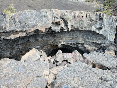
After returning to the car, we drove to and walked the short ½ mile Devils Orchard Nature Trail. The interpretative signage reminded us of the multiple lava flows in the area from 15,000 to 2,000 years ago. Geologists believe that at least nine distinct lava flows account for the variations in the lava in the park.

We stopped at the visitor center to ask about some flowers and the ferret we saw. The visitor center wasn’t open two years ago because of COVID, so we enjoyed looking at the exhibits and chatting with the rangers.

Lava tube at Craters of the Moon

After a lunch of peanut butter, Ritz crackers and some snacks, we left for May about 1:15. We drove through rain north of Arco to Darlington. Acro was the world’s first community to be powered by nuclear generated electricity. In a 1955 experiment a reactor provided electricity to the small town for about an hour. As we drove through the rain, the temperature dropped from 68 to 55. We ran into more rain around Mackey where we saw that the reservoir was being drained to work on the dam. We stopped in Challis for a short stretch break, then on to Hooper Lane where Mark had penne pasta with hot sausage and tomatoes for dinner.  We watched two episodes of Dark Winds, season 2 after dinner.

We went out onto their deck after dark to look at the stars. Very little light pollution exists in the area since ranches here are far apart. Also, with very little humidity in the air and no clouds in this semi-arid environment, the night sky is very clear. So many stars visible that we could hardly make out the common constellations. The Milky Way formed a clear, diagonal band across the sky. While the sky watching was excellent in 2021 compared to the east, the western fires produced a great deal of smoke, somewhat obscuring the sky. However, this year there were no major fires, and the sky was perfectly clear.


Tuesday, September 12, 2023

Golden Spike National Historic Monument

As usual, we woke early and had a cereal breakfast with the last of the Israeli cantaloupe from Green River. After cleaning up the house in preparation for leaving, we took a walk around Price. We wanted to run a few errands in Price and needed to wait until the museum and post office were open. We were glad to see that the wave pool in Price was still in operation, although closed now for the season. The college, now Utah State University Eastern and the Price city park were still there and seemed to be doing well. We returned to the house and finished cleaning up and packing.

We stopped at USUE Prehistoric Museum for postcards and to browse the gift shop. To our surprise, they had no dinosaur cards, but we got some postcards of the San Rafael Swell and other attractions from the area to send to friends. Cindy and Mark went to Walmart for gas, which was 25 cents per gallon cheaper than everywhere else. We planned to meet at the Golden Spike National Historic Monument in Promontory UT.

We drove the familiar Route 6 over the Wasatch Range to Spanish Fork, Utah. It is a very beautiful drive through Utah’s “Castle Country” with the sheer rock canyons bordering US 6 through the mountains. We stopped before we picked up I-15, and Mary drove the busy 6 lane highway (each way) until north of Salt Lake City. Fortunately, the traffic wasn’t as bad at this time of day as it is during rush hours. We left I-15 near Corinne, UT, taking US 83 west to the Golden Spike National Historic Monument

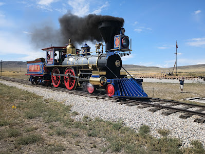
The Jupiter at Promontory Summit

We arrived at Promontory Summit, Utah, shortly before 1:00 PM. Our Interagency Senior Annual National Park Pass got us into the park at no fee. A ranger program was just beginning as we arrived. Her program was excellent, telling the history of the site and the joining of the Union Pacific and the Central Pacific railroads as the “Wedding of the Rails.” Prior to the opening of the transcontinental railroad, travel from the Missouri River to California by wagon took six months. In addition, the trip was very dangerous; many travelers died along the way. 


The ranger dispelled a lot of the stories that we learned in school about the event and told of problems that arose during the last days of the project in 1869. We learned that there were actually four commemorative spikes. A golden spike from California, later given to Leland Stanford Museum; a silver spike was given by the state of Nevada. The Arizona Territory provided an iron spike plated with gold and silver, and the San Francisco New Letter brought a second golden spike. A laurelwood crosstie was laid for the special spikes with holes predrilled to accept the ceremonial spikes whose metal would be too soft to drive. Immediately following the ceremony, the tie and spikes were removed and replaced with a pine tie and iron spikes. A telegraph wire was attached to the final spike to the nation could hear the spike being driven. The whereabouts of two of the four ceremonial spikes are unknown today.

Another story that we found interesting regards the flag flying over the park which had only twenty stars despite the fact that the United States had thirty-seven states in 1869. It seems that no one remembered to bring a flag to the 1869 ceremony. When the organizers realized the omission, they found that a soldier in attendance had a 1818 flag in his personal baggage that was a family memento. It was flown over the ceremony.

A replica of the Jupiter (Central Pacific Railroad) was on display and drove up and down the track for a short distance for onlookers. On weekends, both the Jupiter and No. 119 (Union Pacific Railroad) are on the rails at the park.

We walked around the exhibits in the visitor center and bought more postcards to send to the grandkids. Mary got a stamp in her National Park Passport book.

ATK Rocket Garden

To get to Twin Falls, Idaho, we decided to drive on UT-83 west to avoid backtracking to I-15. Shortly after getting on Route 83 north, we happened upon the Northrop Grumman testing facilities and the ATK Rocket Garden (Autoliv Thiokol) that displayed rocket engines and gave information about each. For many years Morton-Thiokol made rocket boosters for the space shuttle. They became known following the 1986 Challenger disaster. It is believed that failure of O-rings produced by Morton-Thiokol were responsible for the explosion. The company is also known for producing Patriot and Minuteman missiles and other rockets for the military and space industry. We talked to an employee who was working in the gardens near the rocket displays. He told us about the plants and how they did in the growing conditions of northern Utah.

After leaving we had a car lunch of peanut butter, Ritz crackers, Tillamook cheese and snacks as we drove through the flat ranch land north of Salt Lake City. We picked up I-84 near Blue Creek, Utah, and made the short drive to Idaho, stopping at the second Idaho rest stop for a quick stretch break.

The Snake River from Shoshone Falls

Cindy and Mark were ahead of us. Although we had planned to go to Thousand Springs, Idaho, it had been a long day, and we were ready for a stop. We got gas at Jerome, right across from the Day’s Inn where we were spending the night.

After checking into the hotel, we jumped in the truck with Mark and Cindy and went to Twin Falls where we visited the Shoshone Falls State Park overlook. The Interagency Senior Annual National Park Pass got us in free. The park was beautiful with lots of areas for picnicking, hiking, swimming and boating. This stretch of the Snake River is known as “The Niagara of the West” for the waterfalls that can reach over 20,000 cubic feet per second. However, when we visited some water was coming over the falls, but most went through the adjacent hydroelectric plant. After leaving the falls, we drove the short distance to Dierkes Lake, a former lava quarry forming a small lake with a very nice swimming area.

Shoshone Falls

We stopped at the Twin Falls Costco for dinner splitting a couple of pizzas and chicken Caesar salads, all of which were very tasty. We made a quick stop at Walmart for a few things before returning to the Jerome Days Inn.