Monday, January 16, 2017

Returning Home from Southern Arizona

Our alarms went off at 5 am so we could shower and leave for the Phoenix-Mesa Gateway Airport.  We checked the rental Camry back in to Enterprise then checked our bag at the Allegiant desk.  We ate a breakfast of oranges and cold cereal before we went through security.  For some reason we didn’t have the TSA PreCheck status but security at the small Gateway airport wasn’t terribly busy.  While we were sitting at the gate waiting area a fellow struck up a conversation with us.  It turns out that his in-laws are from Frazier’s Bottom, West Virginia.  He had grown up in central Kentucky but has lived in the Phoenix area for a number of years.  It was nice chatting with him.
Mary & I were seated about 10 rows apart.  Since selecting seats carries a significant extra charge with Allegiant we typically opt to sit wherever we end up.  Sitting in row 9 I was in the baby section.  My seatmates, an older couple from Cincinnati, remarked that they had never seen so many young babies on a flight.  We were fortunate that none of the infants was much of a crier and the trip was fairly quiet.  We arrived at CVG in northern Kentucky on time a little after 1:30 pm.
Because we were confused regarding the place where hotel shuttles pick up passengers we missed a couple of opportunities to get back to our car at the Hilton parking area.  We arrived at the correct pickup point as the shuttle was just pulling out so we had a bit of a wait.  We got back to the car and drove home on the AA Highway.  When we arrived in Barboursville we stopped at Walmart so we could have something for meals in the coming week.  We decided to pick up dinner so we stopped at the Arby’s in Ona for sandwiches.  Mary got a reuben and I had a brisket sandwich and we split an order of fries.
We got the water and crucial appliances turned on and started preparing for work and the week ahead.  We estimate that the expenses for the week came to about $1000 which was quite a bargain.  Our expenses were much less since Whittingtons split the house and car rentals as well as fuel and food items for breakfast and lunch.  Because we share a lot of interests with Mark and Cindy we would gladly go on another trip with them.  Like us, they enjoy going out into the desert and walking around.  In the evenings and in the car Mary and Cindy enjoy playing games and chatting.  Mark and I enjoyed irritating them and catching up.  We look forward to another trip together.

The map below shows places that we visited on our trip.  You can zoom in to see additional detail or click on any of the tagged places to see more information on that attraction.  We drove a total of 1355 miles in the week that we were in southern Arizona.


Sunday, January 15, 2017

Mission San Xavier del Bac & Kitt Peak

Interior of San Mission Xavier del Bac
We got up around 5 am after sleeping well and started packing up for leaving the Copper Casa AirBnB.  We have been very pleased with our stay here.  The house was very clean and comfortable.  It was convenient to the area attractions that we visited and our host, Laurie, couldn’t be most pleasant.  In addition, the rates were quite fair.  We will be using AirBnB again for our travel plans.
While at the Old Tucson Studio, we heard that the Mission at San Xavier del Bac was a “must see” attraction near Tucson.  We made the one hour drive from our rental arriving at the mission as the morning service was concluding around 10 am.  We sat in the chapel for a bit and admired the beautiful interior décor.  There was a small but informative museum with artifacts from the mission’s over 300 year history.  We watched a short video narrated by Linda Ronstadt showing the efforts by restoration teams to stabilize the structure and art of the church.  We walked up on grotto hill to see the Moorish exterior architecture with the domes and to see the mission’s Latin cross shape.
Mission San Xavier del Bac
Most of the church’s parishioners are members of the Tohono O’odham nation who are believed by many to have descended from the Hohokam culture.  These are the people who built Casa Grande just southeast of Phoenix.  The name Tohono O’odham means “Desert People” in the Tohono O’odham language.
View of Mission San Xavier del Bac from Grotto Hill
By the time we finished touring we were starting to get hungry so we went to the ramadas in front of the mission where Tohono O’odham families sell food.  There were perhaps a dozen of the pole structures providing some shade from the desert sun for the native families preparing food for exiting worshipers and tourists.  Mary, Cindy and Mark had fry bread with either honey or cinnamon and sugar.  I had an Indian taco on fry bread.  It had been a long time since any of us had eaten fry bread.  We all enjoyed our snacks before heading southwest toward the Kitt Peak National Observatory. 
Ramadas with fry bread prepared by Tohono O'odham families
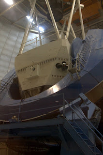
We took Arizona 86 for about an hour going from an elevation of about 2300 feet to Kitt Peak at 7000 feet above sea level.  The air temperature dropped significantly as we drove up the mountain to around 36 degrees.  The blowing wind and icy rain made the day feel even worse.  When we arrived at Kitt Peak National Observatory a tour of the 2.1 meter telescope had just started.  The scientist explained the importance of the research that is done at Kitt Peak and the variety of telescopes on the property.  We learned that the site was selected because the altitude between 7000 and 8000 feet was ideal and that the dry desert air consistently made observations of distant objects very clear.  The Tohono O’odham agreed to permit the observatory to be placed on their land when the observatory was built in the early 1960s.  After learning about the observatory we drove a short distance to the 2.1 meter telescope.  This scope has been updated and used for all sorts of research by a number of agencies.  Our guide told us how the mirror was made and the procedure for recoating the reflective aluminum layer of the surface of the large curved mirror.  We returned through the cold to the visitor center and waited for our 1 pm tour of the Mayall 4 meter telescope.
Mayall 4 meter telescope
The volunteer guide came in and told us that the tour may be cancelled.  It is the observatory’s policy to not visit the 4 meter telescope if the wind is over 50 miles per hour.  He said that the wind is currently at 40 mph and had been gusting to nearly 100 mph earlier in the day.  The guide decided to attempt to visit the telescope since the wind didn’t appear to be strengthening.  We were amazed at the size of the telescope whose mirror was over 16 feet in diameter.  The surface of the mirror is so precise that if it were 3000 miles across there would be less than one inch of irregularity in the surface. 
There is normally a great view from the windows around the Mayall 4 meter telescope but the fog was so thick that we could scarcely see each other in the dense fog.  We walked around the telescope for a bit then drove back down to the visitor center to prepare for our drive back north toward Phoenix.
As we drove down the mountain the air cleared and the temperature warmed.  Within a few minutes we were out of the fog and back into more typical southern Arizona weather.  As we drove northeast of Rt. 86 we were stopped by the US Border Patrol who checked to determine that we were all US citizens.  We picked up Interstate 10 north and continued toward Phoenix.
By the time we were at Casa Grande we were feeling hungry so we stopped at Sho-ga Japanese Restaurant.  Mary, Cindy and I had tempura and Mark had teriyaki beef.  We all enjoyed our meals.
We continued north on I-10 to Sky Harbor Airport, the largest airport in Phoenix.  We dropped Mark & Cindy off at the Avis Car Rental area so they could pick up a rental car for a couple of days.  Although we had to fly home on Monday morning, the Whittingtons were going to visit with friends in Phoenix on Monday then fly home on Tuesday.
We drove back to Chandler and checked into our motel, the Super 8 Chandler Phoenix.  The motel was only $54 and was clean enough but was not a great place to stay.  Mary was unable to print our boarding passes at the lobby computers but was able to get the front desk to print them for her after a good deal of effort.  The motel was fairly noisy until around 11 pm but that wasn’t surprising since a NFL playoff game was in progress.  Later in the night the place quieted down and we were able to get some sleep.


Saturday, January 14, 2017

Old Tucson Studio and Saguaro National Park East

We arrived at the entrance to Old Tucson Studios when they opened at 10 am.  This area was the site where scenes from many well-known Western movies were filmed.  Some of the movies that had scenes filmed there include: Joe Kidd, Outlaw Josey Wales, Tombstone, 3:10 to Yuma (the 1957 version), The Bells of St. Marys, The Three Amigos, Gunfight at the OK Corral, The Frisco Kid and many more. Several John Wayne movies were filmed here including El Dorado, Rio Lobo, Rio Bravo, McLintock and Stagecoach.  In addition, a number of television shows were recoded here including most episodes of The High Chaparral, a few Bonanza, Highway to Heaven, Little House on the Prairie, Kung Fu, Rawhide, Have Gun Will Travel, The Big Valley and the Rifleman.  We had a two-for-one coupon in the booklet that the rental owner left for us that got both of us admitted for $20.
We took a quick guided walking tour of the property that gave us some background of the movies that were filmed here.  Our guide had a good presentation style and a lot of knowledge of the movies filmed there.  The studio was built in 1939 but wasn’t used between 1941 and 1945 due to the war.  Many of the original buildings were made of adobe and built to resemble structures that may have been found in a typical Old West town.  Over the years, there have been buildings added and torn down.  Another location in the Tucson area provides additional options for filming locations in an Old West town.  There have been few movies filmed here since the 1970s since the Western film genre isn’t experiencing the popularity that it enjoyed in the 1960s and 70s. 
We saw the train that Clint Eastwood drove through the saloon in Joe Kid.  The same train was used in Tombstone, Rawhide and the Life and Times of Judge Roy Bean.  The blacksmith shop is there where Dean Martin as Dude had his head dunked in the water trough in the 1959 movie, Rio Bravo.  The old mission has been used in a number of films.  The hotel and several street scenes from McLintock were shot in Old Tucson Movie Studios.  We were most amused that the Chevy Chase, Steve Martin and Martin Short movie, The Three Amigos was filmed at Old Tucson Studios.  The El Toro Cantina was covered with a stucco finish to make it look more like a Central Mexican bar. 
We watched a short film in Rosa’s Cantina about John Wayne’s time at Old Tucson.  A number of people who worked at the location spoke very well of Wayne’s personality and positive attitude.  We went through the museum where we saw costumes and artifacts that were used in many movies and television shows that were filmed there. 
As we were leaving the sky started to cloud up and it appeared that rain was threatening.  We have had rain in the forecast for the past couple of days but so far there had been no rain.  The temperature was in the low 70s but a light breeze made it feel cooler.  Since it was nearly 1 pm we were hungry and made a quick stop at a nearby Wendy’s Restaurant. 
We drove East across Tucson to the part of Saguaro National Park that we didn’t visit on Wednesday.  The park is in two sections on the eastern and western sides of Tucson.  We were at the western part on Wednesday to we wanted to visit the eastern part today. 
There was a great deal of traffic in to the area.  We didn’t know whether the larger crowd was because the east side is more popular or whether it was because today was Saturday.  Once we got past the visitor center, however, we really didn’t see a huge number of people.  We drove the loop road to the Mica View Trailhead where we hiked back to the Pink Hill Trail then followed the Javelina Wash Trail back to near the parking area.  It was a nice walk.  We noticed that the area was very different from the west side of the park.  There were fewer palo verde trees and more mesquite.  There were prickly pear, jojoba and chollo but they seemed to less dense that on the east side.  There was a definite difference in the number of saguaro cacti with the frequency much lower on the east side.  As we walked along the trail a thunderstorm blew up.  It wasn’t a concerned since the rainfall was only .01 inches.  We saw a coyote on the road and a few hawks flying that we were unable to identify.  We also saw gila woodpeckers and acorn woodpeckers, cactus wrens, towhees and one roadrunner.  We spotted many jackrabbits and a few cottontails.  We were hoping to spot a javelina but never spotted one.  We did see where they had been digging in the bottom of a wash.
When we got back to the car we continued around the loop road to the trailhead for the route to the site of the Freeman Cabin, the home of early settlers to the area.  The trail was only about a half mile and was a nice walk to the location that once held an adobe cabin.  Over the years, the adobe has been eroded to leave only a pile of clay.
On our way toward the Freeman Cabin Trailhead we spotted a beautiful rainbow so we stopped and had to take snapshots.  The area is very photogenic and it is easy to take attractive photos in this scenic area.

We went to dinner at Paco’s Mexican Restaurant on Grant Avenue, not far from our rental.  The restaurant isn’t large with only about 10 tables but the food was very good and inexpensive to we all enjoyed our meal. We returned to our rental home and crashed.  Mary & Cindy played cribbage while Mark & I watched the New England-Houston playoff game. 


Friday, January 13, 2017

Fort Bowie and Chiricahua National Monument

For the first time since we have arrived in the West, we were able to sleep in a bit.  I awoke a little before 5 am and came out to the living room to catch up on the day’s emails.  We had breakfast and packed a lunch before heading out to the Fort Bowie National Historic Site.  This military installation was named for George Washington Bowie (he pronounced it “Boo-ee”) when it opened in opened in 1862 as a means to assure that the Arizona Territory became a union, not a Confederate state.  As the Indian Wars heated up in the area, Fort Bowie became important in the quest to control the local Chiricahua Apache tribe, led by Cochise. 
One of the main ways that the fort was to assure control was by securing access to the nearby spring.  The water was not only used by the soldiers at the fort but by civilians in the area surrounding the fort.  In addition, having the fort there, the Apaches could not access the water without going through the fort.  There is no known family connection between General George Washington Bowie and Jim Bowie of Alamo (and Bowie knife) fame. After the Apaches were banished to the Southeastern US, Fort Bowie was abandoned in 1894.  Many of the wood beams and other materials were scavenged by people from the town of Bowie since wood was scarce in the area.  At this time only the stone and adobe foundations remain.
We walked around the ruins of structures at the fort including the barracks for the infantry and cavalry, officers’ quarters, a hospital, school, blacksmith, mess hall, cistern and other necessary structures.   We walked down to the spring and heard a great deal of history from the volunteers and rangers at the visitor center.
From Fort Bowie we drove to Chiricahua National Monument and checked in at the visitor center.  The area is known for tall spires of rock which gives the Chiricahua their name since Chiricahua is Apache for “standing rock.”  We checked in at the visitor center at the bottom of the mountain and learned that they are awarding pins to hikers who complete at least a five mile hike during a visit to the park.  She suggested a .75 mile walk around the Massai Trail at the top of the mountain that includes a number of interpretive signs and a good overview of the area.  She then suggested that we walk the .3 miles to the Echo Canyon Trail which is 1.6 miles, the Hailstone Trail which is 1.3 miles and the Ed Riggs Trail which is 1.6 miles.  That sounded good to us so we headed off.  The first loop, the Massai Trail was very easy walking around a loop that shows many of the types of formations in the area.  Signage told how a volcanic explosion about 27 million years ago caused hot volcanic dust to settle in the area.  This dust fused to form a resistant layer of tuff as a cap over the existing sedimentary rock layers. 
We moved the car a short distance to the Echo Canyon parking pot, grabbed some water and snacks and headed down the longer trails.  All of the trails were well maintained and fairly easy walking although there was a good deal of elevation change.  We saw a number of other hikers on the trail including several groups on hikes.  The area had burned in 2005 and many dead trees were standing and some had fallen over the trail but the park service had done a good job of clearing a path.  There was a nice mixture of smells on the trail including cedar and freshly cut pine from the cleared tree trunks.  
The views of the rock formations were breathtaking.  There were too many balanced rocks, window rocks and slots to count.  Mark commented that any one of these formations back in the East would have an entire state park for that formation.  Here there are thousands of interesting rock figures in one place.  Some of the rocks had weathered to resemble faces or objects with a little imagination.  
After we connected to the Hailstone Trail from the Echo Canyon Trail we saw a formation of white volcanic pellets that were about a half inch in diameter that looked like hailstones.  These ash pebbles had fused into a white mat that was along the trail.  The Ed Riggs Trail brought us past many more rock features and eventually back to the parking area.  We had a drink and drove down the mountain to the visitor center to report that we had completed the five mile “Rock the Rhyolite” challenge and to claim out award pins.  Although we arrived after the 4:30 closing time, the friendly ranger still gave us our pins.
On the way out of the park we stopped at Faraway Ranch which included the cabin of the Riggs family.  Ed Riggs had married one of the Erickson daughters, Lillian, when he returned to Cochise County after World War I.  Ed made a home of the Erickson property where his in-laws had settled in the 1880s.  We also walked out to the cabin of the Stafford family which was about a half mile from the Erickson and Riggs cabins.  It was the Staffords who owned a horse that was stolen by a Chiricahua Apache named Massai or Big Foot.  Massai was chased into the mountains that are now part of the Chiricahua National Monument where he disappeared never to be seen again.  Folklore holds that Massai walks the mountains to this day.
We made a quick stop by the cemetery where the Erickson family is buried then started the two hour drive back to our rental.  It was too dark for Mary and Cindy to play cribbage so they read some ebooks as we drove back.  If we had time available, I would have liked to have spent a little time in Wilcox, Arizona which was home to cowboy actor and singer, Rex Allen.  Allen was known as “The Arizona Cowboy” and was probably best known for his work as a narrator on many films including Disney nature movies. 
We got back to Copper Casa around 7:30 and warmed up leftovers from our Mexican and Italian meals as well as the tamales.  We ate well and enjoyed the meal. 


Thursday, January 12, 2017

Tombstone, Bisbee and Cochise Stronghold

Because we had a two hour drive to our destination we left our rental unit a little early this morning.  We arrived in Tombstone a little before 10 am and got a parking spot beside The Birdcage Theater, an infamous brothel.  We walked along the street as shops were opening and the town was preparing for the day.  We purchased a guided tour on the trolley for $12 each that included a gunfight act. 
Our trolley driver and guide was very knowledgeable about the history of Tombstone and told us that the town was founded by an ex-military man who planned to search for silver ore in the area.  His commanding officer told him that all he would find there is his own tombstone.  When he discovered a rich deposit of silver he founded the town and called it Tombstone.  A few years later in the 1880s the town had over 20,000 residents, over 120 bars, many brothels and was a true sin city.  There were also a number of cultural features including many churches and even an opera house.  The house that Wyatt Earp built is still standing as is the Oriental Saloon, the Crystal Palace Saloon, City Hall and the Courthouse, all built between 1880 and 1882.  
I was impressed that nearly all of the structures in Tombstone were original to when the Earps ruled the streets.  The “newer” structures were built in the 1880s after fires in 1881 and 1882.  Of course, most of the buildings have been renovated or repurposed over the nearly 140 years but at least the town wasn’t built recently to look like old buildings.  A helpful guide at the Tombstone City Hall told us that at one time Tombstone was the largest city between St. Louis and San Francisco.  The trolley tour ended at the site of one of the silver mines where there was a western comedy show.  The humor was corny but we really enjoyed it.  The actors did a good job of working the small crowd and bringing some western figures to life in a humorous way. 
After the show, we walked around town some and stopped by the OK Corral.  The actual gunfight between the Earps and the Cowboys took place a few yards from the OK Corral but that was the nearest feature.  The weather was very nice at nearly 70 degrees with a light breeze.  Since Tombstone is over 4500 feet, the weather was cooler than in Tucson even though Tombstone is further south.  When we returned to the car we drove the short distance to Boot Hill Cemetery.  We saw the graves of the Clanton and McLaury boys who died at the OK Corral.  We also enjoyed the iconic tombstone of Les Moore (killed by two shots from a .44, no less, no more) and one poor guy who was hanged by mistake.
The drive to Bisbee took about 20 minutes where we went to lunch at the Bisbee Breakfast Club.  This restaurant was reviewed in Roadfood and received excellent recommendations.  We all had burgers of one kind or another and all found our meals to be quite good.  However, the highlight of the meal were the pies.  Their cream pies were at least 6 inches thick.  Mary and Mark had the coconut cream, Cindy had strawberry-rhubarb and I had chocolate cream.  While all of our pies were great, everyone agreed that the coconut cream was spectacular.  The pie filling was more coconut than cream and had a thick layer of whipped topping.  The crusts on all of the pies was thin and crispy complementing the flavor of the pies.  The prices were very reasonable and the portions were large. 
After our meal, we walked around Bisbee and nearby Lowell.  These small towns are just a few miles from the Mexican border and nearby disappeared in the 1970s after the copper mines closed and everyone moved away.  However, a group of artists moved in to take advantage of the affordable property and the nice weather.  This has driven the value of property up in Bisbee.  This is in comparison to Tombstone where many homes, businesses, ranches and lots were available for sale. 
We stopped at the now closed copper mine reading the informative signage.  The mine pit is still open although the mine hasn’t worked in over 40 years.  The pit isn’t as large as the Kennecott Mine that we saw many years ago in Utah but was still a large open pit mine. 
As we drove north on Arizona 80 we came to a Border Patrol checkpoint.  Since Bisbee is only about five miles from the Mexican border it is understandable to have a checkpoint here. While one officer checked our citizenship, the K-9 officer walked around our vehicle.  We made some small talk with the officers for a few minutes then went on our way.  As we continued north we noticed many white passenger vans filled with farm workers heading back south.
After being inspected by the Border Patrol we drove to the Whitewater Wildlife Area when we saw 20,000 sandhill cranes overwintering.  It was quite a sight to behold.  We also saw two species of teal, pintails, shovelers and other waterfowl.  There were lots of birders and naturalists in the area to watch and photograph the birds.  We stayed a good while and enjoyed watching the birds interact including doing their characteristic dance.  It still struck us as odd that there was a large wetland in the middle of the desert but the stream in the area provides the water that is used to do controlled flooding of fields to provide for the needs of the migrating birds.
Along our drive we remarked how different the ecology of the Tombstone and Bisbee areas are from Tucson even though they are only about 100 miles apart.  Unlike Tucson, Tombstone and Bisbee have very few cacti and no saguaros growing.  The dominant vegetation appears to be desert shrubs like mesquite, creosote and sagebrush.  We saw a number of yucca and even some Schott yucca that resembled Joshua trees.
perhaps because of the higher water table there was a great deal more agriculture in this area than we have seen in most of Southern Arizona.  We were even surprised to see large fields of cotton.  As we read up a bit we learned that Pima cotton originated in Pima County Arizona and is probably named for the Pima Apache nation. I guess we assumed that cotton originated in the Mediterranean region.  
We drove up into the Dragoon Mountains to the Cochise Stronghold area where the Chiricahua Apache leader Cochise and about 1000 tribe members held off assault from the US Army for over 7 years.  The area is very rugged and provided a way for the Apaches to live following an accusation of murdering a couple of young white men.  This area is very different still from either the Tucson or Tombstone areas because of the rugged mountainous terrain.  The stream cutting through the mountains allows cottonwood and sycamore trees to grow.  We saw several of the Coues deer that didn’t seemed bothered by our presence.
It took about two hours to drive from the Cochise Stronghold back to our rental in Tucson.  Mary & Cindy played cribbage in the back seat and reminded me of when we would travel in the West with Sarah & Emily in the back of the car.  Mark & I watched for birds and other animals from the front.  We saw several Harris hawks, a few grey hawks, one red tail hawk, one harrier and one great horned owl.  There were many raptors in the distance that were impossible for us to identify.

We stopped off at Fry’s Supermarket to pick up food for lunch tomorrow.  An old Mexican woman was selling her homemade tamales in the parking lot so we picked up six chicken tamales for our supper on Friday.  Since we were still full from our large lunch we had some snacks and crashed a bit before turning in for the night.


Wednesday, January 11, 2017

Saguaro National Park and Arizona-Sonoran Desert Museum

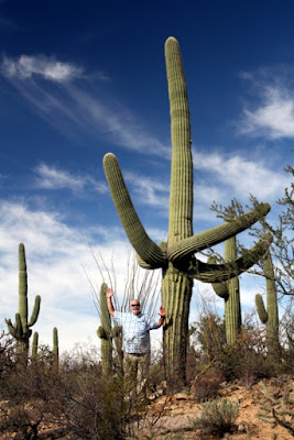
We woke around 6 am and had breakfast of eggs left by Laurie and cereal before heading toward the western part of the Saguaro National Park.  We started our visit by using our National Park Annual Pass for entry which saved $15 on park entry.  We walked around the short trails at the visitor center and read the signs that identified the types of chollo, barrel cactus, mesquite, creosote bush and palo verde bushes.  We saw many saguaro cacti of all shapes and sizes.  The number and size of the giant saguaro cacti amazed us.  Many of them were 30 or more feet tall with arms curving skyward.  Others had what we called “octopus arms” appearing misshapen from whatever forces caused them to bend in odd directions.  Under many of the chollo or mesquite bushes we saw small hedgehog cacti that are generally about the size of a teacup and in clusters of 6 to 10 cacti.  
Several birds caught our attention including a Phainopepla which reminded us of a slim and dark cardinal.  We saw cactus wrens, thrashers and a quail.  According to the naturalist at the nature center there are no snakes out at this time of year but we did see a number of small lizards scurrying about in the underbrush.  Some of these lizards were the Sonoran whiptail lizards that are so often discussed in biology books because of their method of reproduction.  Male Sonoran whiptails develop from fertilized eggs while unfertilized eggs develop into female Sonoran whiptails by a process known as parthenogenesis.  Since no male Sonoran whiptails are known to exist, female lizards lay only unfertilized eggs producing only young female lizards.  It is an interesting and unique process.
We picked up some guides to birds and cacti from the visitor center then drove out to a driving loop to view cacti.  We stopped at several trailheads and walked out to overlooks or scenic locations.  The temperatures were in the mid 70s and a light breeze made the walk very comfortable.  Although we all wore long pants we were wishing that we had chosen shorts for the day.  We stayed in the park until nearly noon then had lunch of peanut butter and crackers, carrots and fruit as we drove to the Arizona-Sonoran Desert Museum.
This largely outdoor museum was a huge display of desert plants, animals and culture.  Our visit started with a raptor show where trainers showed kestrels, peregrine falcons, grey hawks, barn owls and Harris hawks in flight and feeding.  The show was excellent and had visitors up close to the magnificent birds of prey.  We were glad that the Harris hawks were shown since we are fairly certain that they are the birds that we had seen on Monday sitting on top of power poles along Rt. 79.  From there we went to displays of cacti and other succulents all of which were well marked for identification.  
There were inside exhibits of aquatic life of Arizona streams, displays of local rocks and minerals and pollinator gardens.  When we entered the museum we expected to spend about two hours there but when we left at 5 pm when the museum was closing we still hadn’t seen everything there was to see there.  We would be happy to spend a day there any time.
Several local people we spoke with recommended Gates Pass as a place to view sunset.  We discovered that it is a very popular place with locals and tourists alike.  
We watched as the sky changed from the turquoise blue to peach to red.  It was a nice way to end the day.  A local Tucson resident who was there recommended Guadalajara Grill near our lodging for dinner so we decided to give it a try.
The restaurant was obviously popular from the traffic into the parking lot on a Wednesday night.  We were seated quickly and had salsa made to order at our table.  Cindy had a chimichanga, Mark had fajitas, Mary had a steak and I had a combo that included a tamale, a chili relleno and a gordita.  Everyone enjoyed their meal and leftovers came back with Mary & Cindy. 

It appears that we will be visiting Tombstone and some of the nearby attractions on Thursday which means an early start.  With all of the walking on desert trails today I am certain that we will all sleep well tonight.


Tuesday, January 10, 2017

Biosphere 2 and Casa Grande

I guess because my 60 year old body is still running on Eastern Time, I awoke at 3 am.  Not surprising since that is 5 am at home and that is my normal time to awaken.  I caught up on some things, responded to some emails and watched a couple of episodes of I Love Lucy on the living room television.
When I heard Mary stirring I made breakfast of some of the fresh eggs and homemade bread that the property owner left for us.  After cleaning up and discussing plans for the day, we went to the nearby Fry’s Supermarket which is a partner with the Kroger chain.  Figuring that we would eat evening meals out, we picked up some things that we might need for breakfast and lunch on the road visiting local attractions.  We always like to have a case of water bottles in the car trunk, especially when travelling in remote desert regions.
Steve at Biosphere 2
After a quick stop at Copper Casa to unload groceries and pack our lunch, we headed northeast to Biosphere 2 Biosphere 2 near Oracle, Arizona.  The passport book that the property owner passed along to us gave us 2 for 1 admission to the Biosphere 2 tour.  That made it $20 for both of us.  Like many tours, we started with a short film that explained what Biosphere 2 was all about.  We then walked through the glass domed structure that encloses 3.14 acres.  When the facility opened in 1991 It was used as a closed system where 8 human subjects would live in a completely self-sustaining environment where nothing, not even air or water, would enter or leave.  Today, the focus of Biosphere 2 has completely changed.  It is now owned and operated by the University of Arizona as a research laboratory where conditions on Earth can be closely simulated.  
Artificial ocean in Biosphere 2
Biosphere is no longer a completely closed system and visitors, like us, are permitted to enter and leave through the airlock doors.  A number of things surprised us about Biosphere 2 including the fact that there was no Biosphere 1 structure.  Biosphere 1 is Earth!  The Biosphere 2 was intended to model conditions that may exist on a “replacement Earth” that could be built on another planet or following an environmental disaster.  We also learned that the human habitation project was not considered a failure as the press reported.  It is true that during the two years that the 8 people lived there, the oxygen levels dropped despite the number of plants growing in the facility.  During the experiment, supplemental oxygen needed to be added to the atmosphere on three occasions.  The current explanation is that the deep concrete pad on which Biosphere 2 is built continued to absorb oxygen for many years after construction causing the atmosphere is be deficient in the gas required by the people and animals living therein.  In addition, a medical emergency required one resident to be removed from the Biosphere 2 for a few hours when she cut the tip of her finger off while gardening.  Finally, when the Biospherians left following their two year stay they were only able to take in about 2000 Calories per day which was less than what they would require to sustain them.  That all being said, the whole project was an experiment intended to teach the researchers about the challenges of recreating Earth conditions. 
Biosphere 2
Today the facility has a number of areas where University of Arizona researchers and others can investigate a variety of environmental conditions.  We learning that the technical crew working on the movie, The Martian, came to Biosphere 2 to learn what would be involved in creating an autonomous life zone on another planet.  The last thing that we learned is that Biosphere 2 was constructed using only donated private money.  Even today the project depends on donations and fees paid by tours to supplement the grants that are used to operate and maintain the research facility.

Fish hook barrel cactus
We had lunch in the parking area of Biosphere 2 which was the cheese and bread that we purchased earlier at the supermarket.  We also had Envy apples followed by our usual peanut butter on Ritz crackers as we drove north toward Casa Grande Ruins.  Along the drive we stopped a few times to admire and photograph some of the interesting vegetation, especially the many cacti.  Of course, the saguaro are the most obvious and recognizable botanical feature of this part of the desert.  However, there were many types of prickly pear cacti and we especially liked the fish hook barrel cacti that are always slightly tilted toward south and have a ring of bright yellow fruits at the top this time of year. 
Steve at a marker where Tom Mix died.
We traveled up Route 79 and passed over Tom Mix Wash, a small dry river bed where cowboy actor, Tom Mix, crashed his yellow Cord automobile in 1940 after failing to notice a detour sign.  Mix was a pioneer in the Western movie genre and set the standard for television and film cowboys for many years.
We checked in at Casa Grande Ruins National Monument and bought an annual National Park pass to enter.  We have found for us that the annual pass is a much better deal than paying individual park entry since the pass will provide entry for the entire group.  Casa Grande was a very good stop for us.  We learned that the area was occupied by the Hohokam culture since about 300 BC.  These people lived in earthen structures using caliche mud along with cactus ribs and wood from the mountain area to construct their homes and other structures.  It is believed that the current structures on the 400+ acre area were constructed around 1350 and had over 2000 residents in four separate walled communities.  Each community had a seven foot tall packed mud wall encircling a number of single story dwellings, oval ball and game courts, cooking areas and many other aspects of daily life.  Casa Grande is unique by having a large three story building at the center of one of the walled communities.  It is not known the purpose for this large structure although there are several openings that are aligned to astronomical phenomena including one hole in the six foot thick outer wall that is aligned to the summer solstice.  Another one is set to observe the lunar standstill that occurs every 18.6 years. 
600 year old structure at Casa Grande
When Casa Grande was discovered by Spanish explorers in 1694 the area was long abandoned.  It is speculated that the Hohokam culture dispersed from Casa Grande around 1450.  It is believed that the culture formed or assimilated into many tribal nations that still exist in the region today.   Today, the area is protected as a National Monument and has a steel structure over the 700 year old mud building to protect against further degradation.  We had a nice tour with a small group that was very informative and interesting.  After the tour, we walked around on our own taking some snapshots and reading the interpretative signage along the paths and exhibits. 
We left Casa Grande to make a quick stop by the nearby Walmart to buy a cheap Styrofoam cooler to take lunch and drinks over the next week.  We saw that there was an Earthcache along a road leading from Casa Grande to I-10 so we decided to stop.  This cache was showing how much the land has subsided near an irrigation well.  As water was removed, the surrounding soil level has dropped over 24 inches.
Sunset in the desert
On our drive toward Phoenix us I-10 we could tell that the sunset was going to be beautiful.  We knew that we had a good bit of time before we had to pick Mark & Cindy up at the Sky Harbor Airport in Phoenix so we made a stop to take some snapshots.  As the sun set it changed from bright blue to include clouds with peach colored bottoms that eventually became bright red.  It was spectacular.  Although their flight wasn’t scheduled until 7 pm we arrived at the airport’s cell phone lot a little after 6 pm and enjoyed the evening.  We picked them up outside the baggage claim area and headed south toward our B&B in Tucson.  We stopped for a good and fun dinner at Buca de Beppo.  Mark & Cindy ordered baked rigatoni and we got my usual Italian choice, chicken parmesan.  Meals there are family style so we shared some of all and still had a large portion of rigatoni to bring back to the room. 

Mark & Cindy seemed to like Copper Casa and picked out their rooms before we all turned in for the night.


Monday, January 9, 2017

Arriving in Tucson

We were excited to get underway for our trip to the Southwest.  Seeing temperatures of 8 degrees on our outdoor thermometer made us even more anxious to get to southern Arizona.  We finished closing the house out to be away by turning the whole house water off, as well as the water heaters, router and unplugging major electronics.  We were out the door and on the road before 7 am.  We learned that Mark & Cindy would arrive in Mesa at 6:30 on Tuesday.  The ice in Eugene and Portland cancelled all of the flights to and from Western Oregon airports on Monday.
It took about two and half hours to get to Cincinnati on the AA Highway.  We stopped at the Cincinnati Museum Center to pick up our renewed membership cards.  The museum membership will get us free or discounted admission to many museums in Arizona.  We were at Sarah’s house before 10:30 and enjoyed an hour of playing cars with Peter.  We read a couple of books and had a nice lunch of Sarah’s chicken corn soup.  We delivered their Christmas presents that we had been holding for them and most of Sarah & Greg’s birthday presents. We left their house at noon to drive to the airport.
There wasn’t much traffic at that time of day so we arrived at the parking area around 12:20.  We are trying a discounted parking service at the Hilton Hotel in Florence, Kentucky.  They offer airport parking including a shuttle to and from the terminal for $3 per day.  We even found an online coupon bringing cost down a little.  The service is called OneStopParking.  We parked at the hotel then waited for the shuttle which runs every half hour.  Boarding at 12:30 put us at the terminal by 12:50 or so.  Checking in with Allegiant was quick and easy.  We were a little concerned about our bag’s weight but it turned out to weigh two pounds under the 40 pound limit.  Our TSA PreCheck status let us go through security quickly and easily. 
The flight from Cincinnati to Tucson boarded on time and appeared to be completely full.  When we were preparing to push back from the gate the captain came on the speaker informing us that departure would be delayed because “there are some screws loose in the right engine”.  One of my seatmates commented that his announcement wasn’t exactly comforting.  The repair and accompanying reports took a little over 30 minutes and we were underway.  Mary was seated in the row behind me because Allegiant charges a fee to choose seats together.  I enjoyed chatting with the two fellows in my row.  One was a young man who had recently relocated from Columbus, Ohio back to Phoenix where his family lives.  He told me that his grandparents came to Tucson in the 1940s from Red Jacket and Matewan, West Virginia.  The other man was a transplant to Phoenix from Kentucky over 12 years ago.  He runs the table games at one of the Native casinos in the Phoenix area.  Both were interesting people and made the four hour flight go faster.
At the Phoenix airport Mary waited on our checked bag while I picked up the rental car.  I was glad to get a new Camry.  Although black didn’t seem to be the best choice for the desert climate we were glad to have a nice car for the week. I returned to baggage claim so Mary could contact to the B&B owner to let her know our timetable.  It took about two hours to get from the airport in Mesa to our B&B including a stop at a fast food drive through. 
We were met at Copper Casa by the owner, Laurie, at 7:30.  She was very pleasant and showed us everything that we might need to know.  The house is a tastefully decorated three bedroom, two bathroom home in a quiet Tucson neighborhood that is not far from connections to the highway and many attractions that we plan to visit.  The house is well equipped with linens, dishes, cookware and anything we might need for our stay.  Laurie even provided home-baked bread and a bowl of eggs from “her girls.” We tried to stay up by watching television but went to bed a little after 9 pm.  Since it was 11 pm back at home, our bodies were telling us that is was time for bed. This was our first stay at an AirB&B rental but everything seems great.
We will plan a outing for Tuesday that will put us in Mesa by 6:30 to pick up Mark & Cindy.  The weather here is forecast in the mid 70s so we are looking forward to the day.